


 text in
  English (pdf)
 Article in xml format
 Article references
 Send this article by e-mail
 Cited by SciELO
  Cited by Google
  Similars in
SciELO
Similars in
SciELO  Similars in Google
 Permalink
INTRODUCTION
The Peruvian anchoveta (Engraulis ringens) is a pelagic species most abundant in the Northern Region of the Humboldt Current System (NRHCS) and has been sustainable over the last decades. The management measures decreed by the Vice-Ministry of Fisheries of the Ministry of Production (Produce) are generated by the research activities carried out by the Peruvian Institute of the Sea (Imarpe). Therefore, continuous monitoring is necessary for updating the oceanographic, biological, and acoustic conditions of the population, as this region is an area of high variability regarding environmental conditions and biological production (CSA-UPCH, 2011; Bouchón, 2018). Biological production originates from upwelling, caused by the rise of waters rich in organic nutrients (nitrates, nitrites, among others), which, through photosynthesis, activates their conversion into organic matter for phytoplankton and zooplankton, the food source for anchovetas and other species (Chávez et al., 2008; Espinoza and Bertrand, 2008; Oerder et al., 2015). The main objectives of hydroacoustic survey cruises for anchoveta and other resources are to show the oceanographic conditions, the spatial distribution, and the biomass of anchoveta and other resources, as well as the size range of these species. (Imarpe, 2022). This research will use information from these four research activities to show the spatial variability of anchoveta in short periods of time in the restricted area between the latitudes 06° 00’ and 11° 59’ S.
The distribution of the Peruvian anchoveta is structured and spatially dependent, meaning it undergoes a continuous process with characteristics of autocorrelation and inter- and intra-seasonal distributional differences (Castillo et al., 2015). This spatial variability in distribution is attributed to the dynamics of the cold waters of the NRHCS (Swartzman et al., 2008; Bertrand et al., 2011; Castillo et al., 2018), implying that the ecological niche of the Peruvian anchoveta changes according to its developmental stages, which have different tolerances to environmental variables (Lujan, 2016). Meanwhile, its vertical distribution is constrained by the extent and depth of the epipelagic zone located above the minimum oxygen zone (MOZ) (Gutiérrez et al., 2012)
The first fishing season for Peruvian anchoveta in 2022 was recommended following the results of the 2202-04 cruise, as described in the report titled Status of the northcentral stock of Peruvian anchoveta (Engraulis ringens) as of April 1 and prospects for exploitation for the first fishing season of 2022. This report details the findings of the 2202-04 cruise, including oceanographic conditions, spatial distribution, and acoustic biomass, sizes, biological conditions, and decision tables for determining the maximum total allowable catch limit (MTACL). Consequently, Produce set a quota of 2.79 million tons in the north-central region (the north end of Peru’s maritime domain and 16° 00’ S). This fishing season, aimed at indirect human consumption, began on May 19, 2022, as per Ministerial Resolution N° 00167-2022 of Produce, in the maritime area outside the five-mile coastline, only between a) the north end of Peru’s maritime domain and 06° 00’ S and b) south of the 10° 59’ S and 16° 00’ S; all this, while considering Imarpe’s recommendations, among others, regarding total or partial protection measures for the juvenile fraction, completion upon reaching the quota, and/or environmental or biological circumstances (Produce, 2022a, 2022b). Closed zones are spatial-temporal closures with specific delimitations at sea, implemented due to a high incidence of juvenile fish catch with occurrences of netting. These zones aim to reduce the impact on the juvenile fraction of the stock.
This study will focus only on the restricted area between 06° 00’ and 11° 59’ S. This area was restricted to the industrial fleet during the beginning of the first fishing season of 2022 due to the high incidence of juvenile specimens. Our work considers four research activities carried out by Imarpe between February and June 2022, mainly in the coastal strip of the 55.56 km (30 nm) of the restricted area.
Recording a high percentage of juveniles required exhaustive monitoring of oceanographic changes along the Peruvian coast (water masses, surface thermal anomalies, and primary production) through continuous research activities over various time periods in the main historical fishing area, which could condition the spatial redistribution of the anchoveta. Additionally, it involved recognizing the distribution of different cohorts throughout the entire closed area, as well as updated elements of judgment to adopt the relevant conservation measures. The purpose of the analyses in each activity was to observe the spatial redistribution of the anchoveta, which allowed proposing appropriate management measures during the fishing season while aiming for sustainable fishery.
MATERIALS AND METHODS
Research activities analyzed
For this study, the area between the latitudes 06° 00’ and 11° 59’ S (Punta La Negra-Callao) was analyzed through the following research activities (Figure 1):
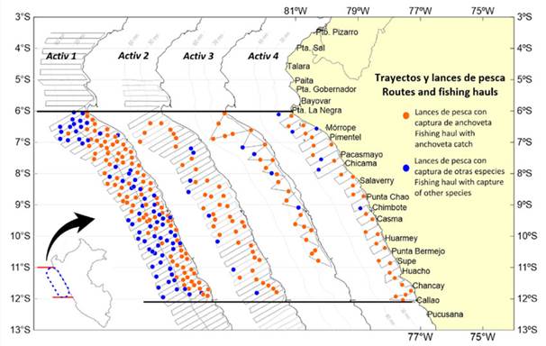
Figure 1 Paths and fishing hauls for the research activities conducted at 06°-12° S between February and June 2022
a. The Hydroacoustic evaluation cruise of the anchoveta and other pelagic resources 2202-04 (Activ 1), conducted from February 15 to April 9, 2022, with the permanent participation of the BIC Flores Portugal, L/P Imarpe IV, and five industrial vessels from the National Society of Fisheries (SNP). Its purpose was to determine the biomass, distribution, and biological-fishery aspects of anchoveta and other pelagic resources along the entire Peruvian maritime coast up to 148.16 km (80 nm).
b. Operation Eureka LXXII (Activ 2), conducted between April 24 and 27, 2022, from Paita-Chala up to 129.64 km (70 nm) off the coast, which involved the participation of 20 larger-scale vessels from the SNP. Its purpose was to understand the distribution, concentration, and biological-fishery conditions of pelagic resources, primarily anchoveta (Produce, 2022C).
c. Biological prospecting of the anchoveta (Activ 3), conducted in the area between Punta Falsa-Huacho up to 111.12 km (60 nm) from the coast from May 11 to 19, 2022, on the BIC Flores Portugal. The purpose was to update information on the spatial distribution and size structure of the anchoveta.
d. Research cruise for hake and anchoveta in the coastal zone between Callao and Punta Falsa 2205-06 (Activ 4), up to a maximum distance of 60 nm from the coast, conducted between May 31 and June 15, 2022. The purpose was to update the information on the distribution of hake and the distribution, concentration, and biologicalfishery conditions of the anchoveta.
Acoustic information
Acoustic data were obtained from the scientific echosounder EK80 Simrad installed on the BIC Flores Portugal, with four sound emission frequencies (38, 70, 120, and 200 kHz). In Activ 1, the EP Andes 52 (SNP) covered an area for acoustic sampling, using an EK80 portable scientific echosounder with three frequencies (38, 70, and 120 kHz). Acoustic calibration was carried out according to the methodology of the International Council for the Exploration of the Sea (ICES) Cooperative Research Report No. 326 (Demer et al., 2015), achieving a ‘very acceptable’
level in all activities according to the established scale, with an RMS value of less than 0.2 dB for the 120 kHz frequency (the frequency used for analyzing anchovetas). In the case of Activ 2, the participating vessels had ES70 and/or ES80 semi-scientific echosounders operating at a frequency of 120 kHz, as well as commercial Furuno FCV echosounders.
The acoustic sampling design was systematic (parallel transects), except in Activ 3, which had a zigzag design. The acoustic sampling unit, or EDSU (Elementary Distance Sampling Unit), was 1 nm for all activities (Simmonds and MacLennan, 2005).
The Echoview software was used for school identification through multifrequency analysis, the characteristics of the echo traces, and the results of fishing hauls, thus obtaining the spatial distribution of the resource. To estimate the biomass of anchoveta, only the 120 kHz frequency was used.
The procedures followed in this regard are described in Castillo et al. (2011). The fishing hauls conducted by Imarpe’s BIC Flores Portugal were carried out using a 360/290 Granton-type midwater pelagic net with an 8 m vertical opening. In contrast, the vessels of the SNP used purse seine nets with a mesh size of 13 mm (Figure 1).
The biomass of anchoveta was considered only in the isoparalittoral areas estimated in Activ 4, which were compared against Activ 1
Biological information
Biometric samplings were conducted aboard vessels using an aluminum ichthyometer with dual graduation, measuring the total length of the anchoveta to the nearest half centimeter. The recorded size groups were weighed with a digital scale (graduated to 0.1 g). This sampling had a simple random design. The size structure of anchoveta in each activity corresponded to the sum of the structure by the frequency of each haul, weighted by the parameters of the length-weight relationship to the values of acoustic integration as described in Imarpe (2020). Finally, for a better separation of the size structures, the Bhattacharya method was employed, by means of the FAO-ICLARM Stock Assessment Tools (FiSAT) software (Gayanilo et al., 1994; Salgado-Ugarte et al., 2005). The parameters of the length-weight relationship (“a” and “b”) used in the biomass estimation were derived from the catches obtained.
Oceanographic information from satellite images
The satellite data used correspond to Level L4 Sea Surface Temperature (SST) monthly averages, with a spatial resolution of 5 km, derived from the OSTIA model (Operational Sea Surface Temperature and Sea Ice Analysis) using in situ and satellite data from infrared and microwave radiometers, as described in Quispe et al. (2019). The Sea Surface Salinity (SSS), also Level L4, albeit with a spatial resolution of 9 km, was obtained from the HYCOM model (HYbrid Coordinate Ocean Model). The chlorophyll-a data (Level L3) with a 1 km resolution come from the MODIS sensor (Moderate Resolution Imaging Spectroradiometer), as described in Xu et al. (2021). These data and images were obtained from the website of the Remote Sensing Functional Area of the General Directorate of Research in Hydroacoustics, Remote Sensing, and Fishing Gear of Imarpe
Analysis of the distribution in the studied área
In the anchoveta distribution graph for each activity’s study area, the inertia and the center of gravity of the NASC (Nautical Area Scattering Coefficient) were added. Inertia is a measure of the dispersion of the population around its center of gravity, meaning the average quadratic distance between fish detections. The NASC is a quantification value of the echosounder expressed in m² nm² and obtained by measuring the energy emitted by a target,
fish, or school (MacLennan et al., 2002; Simmonds and MacLennan, 2005). The formulation for inertia and the center of gravity is described in Bez and Rivoirard (2001) and Woillez et al. (2007):
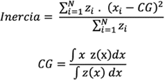
Where: zi is the NASC value of the anchoveta, Xi is the point in space (latitude or longitude) of the sample, and CG is the center of gravity. Inertia is constituted by an ellipse with a major diameter (latitudinal) and a minor diameter (longitudinal), and it is a measure of the dispersion of the group of individuals with respect to the center of gravity. The vertical distribution of anchoveta schools was obtained via Echoview from the exports of the studied regions and classified according to three levels of abundance of volume backscatter strength (Sv), expressed in decibels (dB) relative to 1 m-1, as given by the formula
Where: Sv is the volume backscattering coefficient (MacLennan et al., 2002).
The descriptors of anchoveta schools were also obtained with Echoview. These descriptors were described by Nero and Magnuson (1989), Weill et al. (1993), Scalabrin et al. (1996) and Diner (1998, 2001). They include the following
1. Mean depth is the average depth of the school in the water column, expressed in meters.
2. Sv mean denotes the average energy or mean acoustic density produced by the pixels composing the school, expressed in dB re 1 m-1
3. Sv max represents the maximum energy Sv of the school, expressed in dB re 1 m-1
4. Sv min corresponds the minimum energy Sv of the school, expressed in dB re 1 m-1
5. Asymmetry: This statistic is used to identify whether the acoustic energy data of the school are uniformly distributed around the central point (mean). It is expressed in dB re 1 m-1
6. Kurtosis: This statistic measures the concentration of Sv values near the mean of the distribution, forming a peak, or, conversely, a distribution far from the mean, showing a flattened curve forming tails. It is expressed in dB re 1 m-1
7. Mean height: The average height or measure of the extension of a school along the beam axis. The average distance of the upper and lower distances along each ping that makes up the school is expressed in meters.
8. Length: The measure of the length of the school, or the horizontal distance from the first to the last ping of the school. It is expressed in meters.
9. Area: The area of the school, expressed in square meters.
10. School volume X3D: The estimated volume of the school, assuming a cylindrical shape, expressed in cubic meters.
11. Perimeter: The perimeter of the school, expressed in meters.
12. Elongation: An index of the relationship between the length and height of the school.
13. Fractal Dimension: An index of the shape complexity of the school, where a value of 1 represents a smooth or square contour, and a value greater than 2 indicates a highly complex contour.
14. Circularity expresses the deviation of the shape from a circle.
15. Rectangularity expresses the deviation of the shape from a rectangle. It is an index of the ratio between the area of the rectangle that could be formed by the height and length of the school and the observed area of the school.
16. Image compactness is an indicator of a school’s tendency towards a round shape. It is a statistic that measures the ratio between the square of the perimeter and the observed area of the school. A perfectly circular school would have an image compactness (IC) value of 1.
Computer software
The generated graphics were created using the R version 4.2.0 (CITA) free software with RStudio version 2022.02.3. The packages used include EchoviewR (Harrison et al., 2015) and AcousticR (Pozada, in preparation).
RESULTS
Spatial distribution
In the first activity (Activ 1), the distribution of anchoveta along the 55.56 km (30 nm) coastal strip was primarily dense, i.e., there was a large percentage of the area (70 %) with high concentrations of schools along the coast, located between Punta La Negra-Casma and HuarmeyChancay. Longitudinally, the distribution was broad (found up to 150.01 km (81 nm) from the coast in the Punta La Negra area and between Pacasmayo-Chimbote) and coastal (up to 114.82 km (62 nm) from the coast between Huarmey-Callao).
In the second activity (Activ 2), the dense areas of anchoveta decreased along the 55.56 km (30 nm) coastal strip. High concentration areas were found up to 129.64 km (70 nm) off the coast from Salaverry-Huarmey. Furthermore, anchoveta was found in scattered concentrations 129.64 km (70 nm) off the coast of Pimentel. In general, high concentrations were primarily recorded between Punta La Negra-Huarmey
In the third activity (Activ 3), there was a greater decrease in the dense or high concentration areas along the 55.56 km (30 nm) coastal strip. Dense clusters were recorded at Punta La Negra, Pimentel, Pacasmayo-Punta Chao, and Huarmey-Supe. Given the coverage of this research, it is notable that the distribution of anchoveta would be more extensive in this area. In the fourth activity (Activ 4), the same characteristics were found regarding anchoveta distribution along the 55.56 km (30 nm) coastal strip, i.e., with various high concentration cores distributed at Punta La Negra, Pimentel, Chicama, Salaverry-Punta Chao, ChimboteCasma, Huarmey-Punta Bermejo, and Huacho-Callao. Moreover, due to the research coverage, the distribution of anchoveta would be more extensive in this area.
In these research activities, a continuous distribution of anchoveta was observed along the coast in the evaluated area, showing similar characteristics in the form of extensive areas with high concentrations in activities 1 and 2 and reduced dense area concentrations in activities 3 and 4, as a result of dispersion during these months of the year.
Regarding inertia, which is a measure of dispersion of the weighted eco-integration data, the longitudinal diameter of the ellipse was narrower in activities 3 and 4, due to the coverage of the research. Meanwhile, the center of gravity remained in the central zone of Punta Chao (08° 46’ S) (Figure 2).
Vertical distribution
Anchovetas typically inhabit the surface layer of the sea, down to 80 m in depth. In Activ 1, they were found between 1.3 and 48.5 m deep, with an average of 8.6 m. In Activ 2, they were detected between 1.1 and 43.1 m deep, with an average of 8.7 m. In Activ 3, they were recorded between 1.3 and 49.0 m deep, with an average of 12.3 m. Finally, in Activ 4, they were found at a greater recorded depth, i.e., between 1.3 and 81.36 m deep, with an average of 16.4 m. The deepest schools were found at 07° S. In Activ 1 and 2, a higher abundance was observed, with a predominance of Sv values between -43 and -35 dB, which was deemed ‘very dense’, whereas, in Activ 3 and 4, the predominant Sv values were between -65 and -55 dB, regarded as ‘disperse’ (Figure 3).
Figure 3 Vertical distribution of anchoveta schools by degree of latitude, classified by levels of abundance in the activities conducted from February to June 2022. The smoothed gray line indicates the average of the vertical distribution. In the case of Activ 2 (Operation Eureka) between 07°-08° S and 11°-12° S, the vessels that operated in these areas did not have digital echo sounders.
Characteristics of the schools
The mean depth positional descriptor showed that anchovetas have remained in the surface layer (down to 81 m). In the first months of the year, they were recorded in the surface layer down to 49 m, and between June and July 2022 (Activ 4), they were found at greater depths.
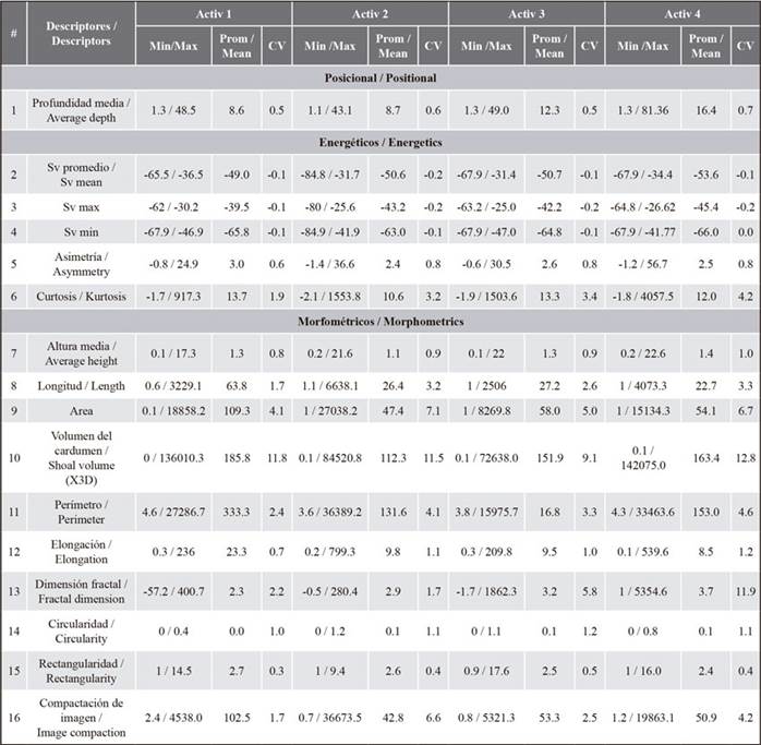
The energy descriptors, i.e., mean Sv, asymmetry, and kurtosis, were higher in Activ 1 (-49.0, 3.0, and 13.7, respectively) due to the higher concentration of individuals in the school or the density that typically occurs during the summer, generating higher reflective or energy capacities compared to winter, when the schools are not as compact, as observed in the results, mainly in Activ 3 (-50.7, 2.6, and 13.3, respectively) and Activ 4 (-53.6, 2.5, and 12.0, respectively). In the morphometric descriptors, there were also differences regarding the dimensional structure of anchoveta schools between Activ 1 and 4, which represented the extremes (the end of summer and autumn, respectively). The descriptors for length, area, school volume, and perimeter showed higher values in Activ 1 (63.8, 109.3, 185.8, and 333.3, respectively) in comparison with Activ 4 (22.7, 54.1, 163.4, and 153.0, respectively) typically because, in summer, there is a formation of larger concentrations and extensions of schools near the coast, due to the retreat of cold coastal waters towards the coast. In autumn and winter, however, the schools disperse and move away from the coast. For the mean height variable, the average values for each activity were similar, indicating that the average height of the school showed no significant differences. The elongation, rectangularity, and image compactness descriptors were also higher in Activ 1 (23.3, 2.7, and 102.5, respectively) compared to Activ 4 (8.5, 2.4, and 50.9, respectively). The coefficients of variation (CV) of the acoustic descriptors also showed a high statistical dispersion of data in Activ 4 due to the greater variability of the schools in terms of their dimensions (Table 1).
Table 1. Statistical dispersion measures of the anchoveta schools’ acoustic descriptors for the research activities conducted between February and June 2022. CV denotes the coefficient of variation.
Size structure
In general, in the first half of 2022, the anchoveta showed a broad spatial distribution in the north-central region, mainly between Paita and Bahía Independencia within 60 nm of the coast, with modal groups primarily of juvenile individuals (< 12.0 cm in total length, TL) and an overlap of adult and juvenile specimens. It was found that, in the area of Activ 1, 89 % of the total biomass of the north-central Peruvian littoral region was observed. The anchovetas exhibited a size range of 4.5 to 16.5 cm TL, with the presence of three modal groups, the main one being 8.5 cm TL and the secondary ones at 6.5 and 12.5 cm TL. In light of the above, it was recommended that the start of the first anchoveta fishing season of 2022 be postponed in the north-central region and that a survey be conducted to observe any changes in the distribution and behavior of the resource.
In Activ 2, somatic growth was noted in the modal groups observed in Activ 1. The main modal group was at 10.0 cm TL, with secondary groups at 8.0 cm and 13.0 cm TL. Additionally, a nucleus at 11.5 cm was observed, which likely corresponded to a fraction overlapped in the main 8.00 cm TL group recorded in Activ 1, with a mode at 10.0 cm TL.
In Activ 3, there was also a recorded growth in the modal groups, with a main mode observed at 9.5 cm TL, corresponding to the modal group growth of 8.0 cm recorded in Activ 2, as well as secondary groups at 12.0 cm and 13.5 cm TL. Additionally, the entry of a new 7.0 cm TL cohort was noted, which stemmed from the extended spawning period of summer 2022. In Activ 4, a wide range of sizes was observed, with three well-defined modal groups. The growth of the new cohort to 8.5 cm TL, the main modal group from the survey to 10.5 cm TL, and the secondary mode at 12.0 and 12.5 cm TL were recorded. In the four research activities, an overlap of juvenile and adult individuals was recorded. This behavior continued until the end of the first anchoveta fishing season of 2022 (Figure 4).
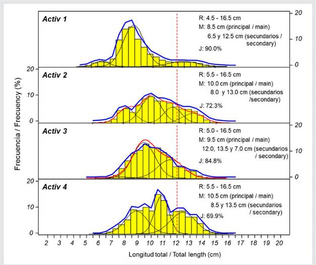
Figure 4 Size structure of anchoveta observed in the scientific activities conducted in the first half of 2022. R: range, M: mode, and J: juveniles. The blue line represents the structures obtained in each activity, and the continuous red line is the size structure calculated with the FiSAT software. The dotted red line indicates 12 cm, which is the threshold dividing juvenile and adult anchovetas.
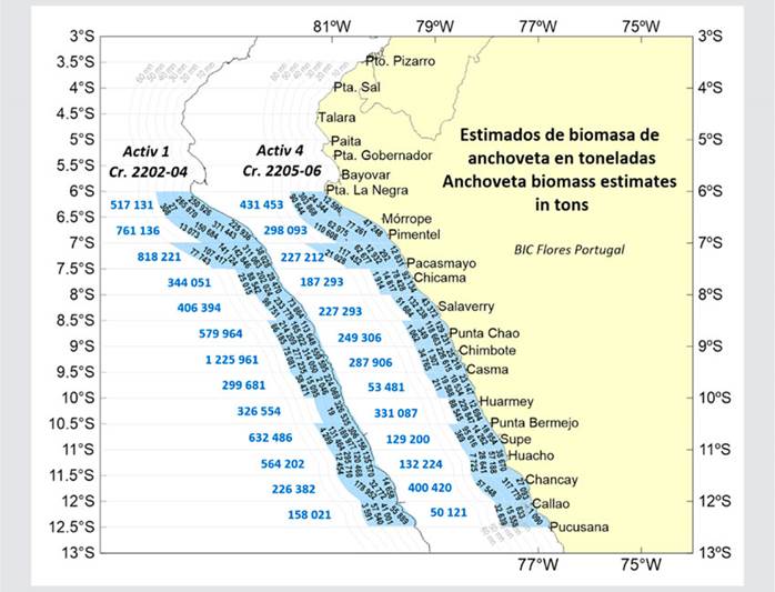
Comparison of anchoveta biomass
The seasonal behavior of the anchoveta was reflected in its biomass in the coastal area. The abundances decreased in the coastal isoparalittoral areas when compared to Activ 1, where 60.46 % of the total biomass was obtained in the 20 nm coastal strip (total biomass estimated at 10.2 million tons). In Activ 1, a biomass of 6.86 million tons was estimated only in the studied isoparalittoral areas, whereas, in Activ 4, a total of 3 million tons was estimated for the same areas (Figure 5). This reduction corresponds to 43.80 % of what was found in Activ 1. The lowest biomass, at 17.85 %, was recorded between 09° 30’ and 10° 00’ S in Activ 4. This indicated a decrease in abundance due to the migration of anchoveta away from the coast and southwards, because of the increase in biomass obtained between 11° 30’ and 12° 00’ S, with 176.88 %
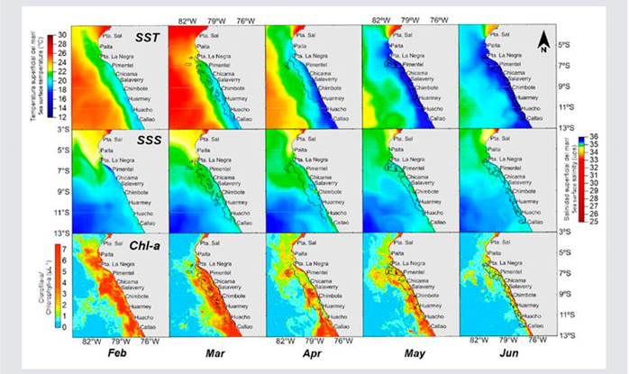
Surface oceanographic conditions
The SST, SSS, and chlorophyll-a from February to June 2022 indicated cold conditions that persisted, leading to a La Niña Coastal Alert, according to reports from ENFEN (National Study of El Niño Phenomenon). The SST was found to be below normal values south of Punta La Negra (06° 00’ S) between February and March, ranging between 18 and 24 °C, implying SST anomalies of up to -2 °C. Subsequently, between April and June, the values ranged between 16 and 20 °C, and the SST anomaly continued to indicate a colder scenario, with greater intensity between 04° and 12° S (-1.0 to 3.5 °C). These cold conditions gradually intensified over the months analyzed.
The SSS from February to March showed a predominance of cold coastal waters (CCW) within 60 nm of the coast. Further away from the coast, there was a noticeable approach of surface subtropical waters (SSW) in the central area. In the following months, there was a gradual decrease in the coverage of the CCW, leading to a greater presence of waters mixed with the SSW, which showed an increased proximity to the coast between Chimbote and Callao, with values exceeding 35.1.
Regarding marine productivity, the chlorophyll-a concentration, an indicator of phytoplankton production, showed variations between February and March in 07-14° S, ranging from 2.0 to 25.0 mg/m³, which were higher than the climatological pattern. Subsequently, in the following months, these values decreased, reaching between 1 and 3 mg/m³ in June, with some areas of higher concentration (up to 10 mg/m³) in the south (Callao-Pisco and Atico-Ilo). For the 100 km coastal strip, the average concentration of chlorophyll-a from February to June 2022 tended to decrease in the studied area, slightly varying below its climatological pattern (Figure 6)
DISCUSSION
Chirichigno and Vélez (1998) considered that the population of anchovetas is structured in two stocks distributed in different regions: one off the north-central coast of Peru (04° 30’-16° 00’ S) and another in the region shared by southern Peru and northern Chile (16° 01’- 24° 00’ S). The north-central region is deemed more significant due to the higher abundances found there (Ñiquen et al., 2000). It is there that the two annual fishing seasons are established and conducted. The first fishing season of 2022 for anchoveta and white anchovy (samasa) resources was subject to extraction limitations between the 06° 00’ and 10° 59’ S latitudes (Produce, 2022a), given the high presence of juvenile specimens found in this area, especially within the 55.56 km (30 nm) strip off the coast. The results of the research activities analyzed in this zone showed that the anchoveta exhibited usual distributional behaviors which were characteristic of the season. In Activ 1 and 2, they were found forming areas of high concentration near the coast in the analyzed littoral zone, leading to high-density compact schools with greater energy capacities or acoustic reflectivity (Sv) and morphometrically of wide dimensions or extensions (corrected length, corrected area, X 3D school volume, corrected perimeter, elongation, rectangularity, and image compactness). In Activ 3 and 4, conducted in autumn, the anchoveta schools migrated towards areas further from the coast due to the extent of the CCW, causing a dispersion of the dense areas, or scattering of the schools, as described by various researchers (Swartzman et al., 2008; Bertrand et al., 2011; Castillo et al., 2018). In these distributions, dispersed areas prevailed, consisting of schools with lower energy capacity and smaller morphometric capacity.
The greater depth in the vertical distribution of anchoveta found in Activ 4 was due to oxygen, whose values were close to 0.5 mL L-1 (the OMZ was recorded between 30 and 80 nm off the coast). The identification of modal groups in the size structure of anchoveta showed the normal somatic growth of the resource from Activ 1 to Activ 4. The first fishing season was supported by the last modal group, measuring 12.5 cm TL and observed during Activ 1, although there was a significant presence of juveniles. Due to the persistent overlap of adults and juveniles in the evaluated area, management measures were implemented, in order to protect the juveniles through the timely closure of marine areas to the extraction activity of the purse seine fleet. Regarding the estimated biomass in Activ 1 and 4, a reduction was observed in the latter, due to the limitations of the studied area, primarily in the coastal strip of 55.56 km (30 nm). Its longitudinal distribution could be greater, considering the cold temperatures recorded in May and June 2022.
The concentration levels and abundance of anchoveta distribution in the first half of 2022 were influenced by oceanographic conditions. In February and March (Activ 1), there was a high concentration of anchoveta due to the predominance of CCW and a high concentration of chlorophyll-a, above the climatological pattern. By the end of April (Activ 2), the situation was similar to that observed in Activ 1, despite the changing environmental conditions. Finally, in May and June (Activ 3 and 4), the concentration of the distribution in the coastal zone was mainly disperse due to expansion towards areas farther from the coast, a typical behavior of anchovetas, despite the fact that, during these months, an approach of SSW towards the coast was observed in the Chimbote-Callao area (indicated by values over 35.1), along with low levels of chlorophyll-a. Castillo et al. (2022) note that the anchoveta is distributed in two zones: an optimal zone, mainly influenced by CCW, and a zone of physiological stress, determined by the mixing of CCW and surface equatorial waters in the north as well as of CCW and SSW mainly towards the south of 06° S. In this stress zone, the anchoveta was found at temperatures lower than 25.0 °C and salinities lower than 35.29. Therefore, a part of their distribution during Activ 3 and 4 would be beyond the 30 nm off the coast.
During the fishing season that began on May 4, 2022 (including the exploratory fishing prior to the official start of the season) and ended on July 24, 2022, a total of 2.34 million tons of fish were caught (84.06 % of the total assigned quota), which will generate around US$ 1000 million in foreign exchange for the country. The ports with the highest landings were Chimbote (588,000 tons), Callao (283,000 tons), Coishco (260,000 tons), and Malabrigo (231,000 tons). To protect the juvenile fish resource, spatial-temporal closures of 150 areas and three additional preventive closures of approximately 20 days each were implemented
The conclusion of the fishing season was based on a recommendation made by Imarpe, as stated in their Report on the development of the anchoveta fishery during the first fishing season of 2022 in the north-central region of the Peruvian sea as of July 17, 2022, as the expected juvenile incidence limit (15.4 %) of the anchoveta resource was reached. As of the date of this report, it was indicated that “the catches of anchoveta in the North-Central Region were composed of individuals with sizes ranging from 7.0 to 17.0 cm TL, with the main mode at 12.0 cm TL”. It was also reported that “the incidence of juvenile specimens reached 25.94 % in number and 17.20 % in weight”, and that, “as of July 17, 95 % of the planned juvenile anchoveta catch (405990 tons) for the First Fishing Season 2022 of the North-Central Region was recorded, and, considering the most recent rate of juvenile catch, i.e., 3455 tons of Juv/ day, the entire fleet would meet the juvenile quota by July 22”, which is why the suspension of extraction activities was recommended in order to protect the recruitment or high rate of juveniles. Regarding this incidence of juvenile catches, Zhou, et al. (2019) mention that catching large individuals unbalances the ecosystem, and that having a proportional or balanced fishery (catching small, medium, and large individuals) can reduce the impact of fishing on the ecosystem structure (reducing the disruption of the natural trophic system in the population structure) and maintain or increase the overall yield.
It is convenient to note that the fishing industry, constituted by the SNP in 2017, is in the process of receiving an international certification by the Marine Stewardship Council (MSC) regarding anchoveta fishery for indirect human consumption. On the other hand, the hydroacoustic assessment methodology implemented by Imarpe since 2021 is undergoing certification by the ICES (International Council for the Exploration of the Sea) and according to the ISO 9001 norm, aiming to provide guarantees regarding the processes and methodologies used for estimating biomass in the context of sustainable the anchoveta fishery.
CONCLUSIONS
In March and April 2022, the anchovetas exhibited a primarily concentrated distribution with high abundances, while, in May and June, they were generally found dispersed due to their longitudinal migration towards areas farther from the coast. This dispersion is a typical behavior of the anchoveta species.
Vertically, the anchoveta was primarily found in the surface layer, down to 50 m deep, although, in the months of May and June, it was found at depths of up to 81 meters due to the presence of SSW near the coast.
The high concentration of anchoveta schools resulted in higher values of energy descriptors (average Sv, asymmetry, and kurtosis) and morphometric descriptors (length, area, 3D school volume, and perimeter). Conversely, a dispersion of the schools led to lower values in both energy and morphometric descriptors.
During the first half of 2022, in the 55.56 km (30 nm) coastal strip of the north-central region, there was a high overlap of juvenile and adult anchovetas, with normal somatic growth observed from Activ 1 to Activ 4. The main modal group, at 8.5 cm TL, grew to 12.0 cm TL in Activ 4. Similarly, the secondary modal group, at 6.5 cm, reached the last activity with a main mode at 10.5 cm TL. Finally, the modal group initially at 12.5 cm reached 13.5 cm TL.
The seasonal behavior of the anchoveta was reflected in its biomass in the coastal area. In Activ 1, a high biomass was estimated in the coastal zone, at 6.86 million tons; while, in Activ 4, it was only 3.00 million tons in the same isoparalittoral areas due to high dispersion.
The high biomasses found in Activ 1 were favored by oceanographic conditions, mainly by the CCW and high productivity, as indicated by the chlorophyll-a concentration.
In the catches of the first anchoveta fishing season, a high incidence of juveniles was reported, leading to numerous spatial-temporal closures in the area, with the aim of protecting the resource.

