


 English (pdf)
 Article in xml format
 Article references
 Send this article by e-mail
 Cited by SciELO
  Cited by Google
  Similars in
SciELO
Similars in
SciELO  Similars in Google
 Permalink
Introduction
Since the establishment of the economic and technological urban agglomeration development zones in China during 1984, the cause of urban agglomeration development zone has been booming. Remarkable achievements have been made in infrastructure construction, foreign capital, economic development, export expansion, talent cultivation, pilot reform, and service to the host city (Wang & Chen, 2016). It has also achieved good results in playing a window to the outside and radiation to the inside. However, there are too many problems in the construction of the development zone, mainly manifested in two aspects: the excessive establishment of the development zone and the rapid expansion of the development zone land, which increase the pressure of cultivated land protection. According to the regulations, the establishment of all kinds of development zones shall be subject to the two-level examination and approval system of the State Council and the people's governments of provinces, autonomous regions, and municipalities directly under the central government. People's governments at all levels below the provinces, autonomous territories, and municipalities directly under the central government shall not examine and approve the establishment of all kinds of development zones. Some cities and counties set up all types of development zones without respecting regulations, resulting in severe waste and repeated land use (Cao et al., 2016; Dong et al., 2016). Also, some provincial development zones set a low threshold for enterprises to enter and cannot realize the intensive use of land, which is also one reason for the rapid expansion of land use in the development zone. Simultaneously, many development zones in the construction process, too much pursuit of "large and complete," the land is going on the extensive development road of quantitative expansion. According to the Ministry of land and resources, there are 6015 development zones (parks) in China, with a total planning area of 35400 square kilometers, equivalent to the entire construction land area of 660 cities and all construction towns in China. Besides, a large amount of cultivated land, especially high-quality and high-yield cultivated land, is occupied in the development zone's construction process, which causes tremendous pressure on the protection of cultivated land in China (Li et al., 2017). Blind expansion of development zones and extensive land use in the zones have severely damaged the development zones and urban construction, which has dramatically damaged the land resources already in short supply. Therefore, evaluating the potential of land use in urban agglomeration development zone is the internal requirement of protecting cultivated land, saving urban construction investment, and strengthening land management (Ding, 2019; Price et al., 2019).
In this paper, the index weight of land resource utilization potential in Baoding high-tech development zone is determined using the combination weighting method. Based on the index weight, the sustainable utilization level of land resources in the high-tech development zone is objectively evaluated by the multi-factor comprehensive evaluation model. The potential of land-intensive utilization in five aspects of expansion potential, structural potential, and intensity potential are combined and analyzed. The potential of land can be changed through the development zone. The combination of unrestricted factors and restrictive factors can calculate the natural quality potential of land remediation in the high-tech zone and put forward the countermeasures for sustainable utilization of regional land, which provides an essential theoretical basis fore planning new villages in the high-tech area.
Basic definitions Regional overview
Regional natural conditions: Baoding's high-tech zone is located in the ancient city of Baoding, with flat terrain, an average elevation of 18.5m, and a slope of 1.0 %o. The foundation's bearing capacity is 18-20t per square meter, with a seismic fortification degree of 7. It belongs to a warm temperate continental semi-arid monsoon climate with four distinct seasons and mild weather. The annual average temperature is 12.3 °C; the coldest month is January, the average temperature is -4.2 °C, the warmest month is July, the average temperature is 26.7 °C, and the annual frost-free period is about 210 days. The precipitation is mainly from July to September, with an average yearly rainfall of 575mm. Four distinct seasons, dry and windy in spring, hot and rainy in summer, cool in autumn, cold and little snow in winter.
Regional location: the central area, east area, and west area of Baoding national high-tech industrial development zone are the primary areas. The central area is located in the north of Baoding City, starting from Torch Road in the East, Zhichang road in the south, Xiangyang North Road, Luxin South Road, Luxin East Road, Luxin North Road, Jianshe North Road in the west, and the north outer ring road in the north, with an area of 5.849km2. The eastern region is located in the east of Baoding City, adjacent to Expressway in the East, Qiyi road in the south, Baoding Teachers College in the West and North, with an area of 0.185km2; the western region and the experimental site are located in Baoding. In the west of the city, the west district area is 1.689km2, 800m from the flood control dike in the east to the west (Li et al., 2017), 337 regiment family house in the west, Jiangcheng road in the north. The experimental area is 2.890km2, from Jianshe Road in the East to the flood control dike in the west, Jiangcheng Road, Baoshen railway, Fuchang road in the south, Kangzhuang road in the north.
Evaluation system
The selected indicators should follow the principles of objectivity, scientifically, representativeness, comprehensiveness, dynamism, and operability to ensure the rationality of the evaluation results (Arneth et al., 2018; Song & Deng, 2017). Combined with the actual situation of land use in high-tech zone and the characteristics of sustainable land use in the county and referring to the evaluation standards of sustainable land use in China and abroad, an evaluation system of sustainable land use with the overall goal of sustainable land use in a high-tech zone is finally established, which includes four criteria levels: land-use level, resource security, economic feasibility, and social acceptability, as shown in Table 1.

Index weight determination
Due to the subjective weighting method's lack of objectivity, the weight determined by the objective weighting method will change with the environment's change. This paper uses the subjective and objective combination method to determine the weight, the combined weighting method, to avoid the shortcomings of the subjective and objective weighting. The analytic hierarchy process (AHP) is a decision-making method that decomposes the decision-making elements into objectives, criteria, schemes, and other qualitative and quantitative analysis levels. In this paper, the AHP method is used to weight the indicators subjectively, and the results are shown in Table 2.

On this basis, the variation coefficient method is used to weight its indicators objectively, and the result of variation coefficient weighting is shown in Table 3. The variation coefficient method directly uses the information contained in each index to calculate the weight of the index. The combination weighting is then carried out; that is, the subjective and objective linear combination is established to obtain the proportion of subjective and objective. The combination weighting value is also shown in Table 3.

Evaluation model of land sustainable use degree
Factors comprehensive evaluation model and fuzzy comprehensive evaluation model are used to evaluate the sustainable use of land. Because many factors affect the sustainable use of land, and applying a multi-factor comprehensive evaluation model is relatively mature, this paper uses a multi-factor comprehensive evaluation model to evaluate the degree of sustainable land use in the high-tech zone (Maranguit et al., 2017). Suppose that there are n sub-objectives B 1 (t),B2 (t),...,B n (t) in the evaluation index system, and each sub-objective is composed of several indexes X i (f), where t is the year, and the constructor:


In Formula 1, B n (t) is the annual evaluation index of the n sub-goal; A (t) is the comprehensive evaluation value of annual sustainability; X i (t) is the standardized value of the i index, that is, the value of each index unified to dimensionless 0 ~ 1. In formula (2), P i (t) is the relative weight of the sub-goal, and Wj (t) is the weight of the total goal. It is necessary to set the land use potential level's judgment standard to evaluate the degree of land use potential vividly and intuitively. According to some researches, the sustainable land use is divided into five grades, and the corresponding comprehensive evaluation values of each stage are < 0.25 (very low), 0.25-0.45 (low), 0.450.65 (medium), 0.65-0.85 (high), and > 0.85 (very high).
Calculation of the potential of intensive use of land in the high-tech zone
(1) Calculation of expansion potential
The calculation formula of expansion potential is as follows: the area of available land = the land's total area in the development zone - the area of supplied state-owned construction land - non-available land.
(2) Calculation of structural potential
Structural potential = area of built-up urban construction land x (ideal value of industrial land rate - current value of industrial land rate).
(3) Calculation of strength potential
Strength potential = area of completed industrial and mining storage land x(I I - I P ) /I I , where I I is the ideal value of comprehensive plot ratio of industrial land, building density of industrial land, input intensity of fixed assets of industrial land, output intensity of industrial land, and Ip is the current value of index.
(4) Measurement of management potential
Since the establishment of the high-tech development zone, the land management has been strictly controlled, and the idle land has been identified and disposed of in time (Meng et al., 2018; Houghton & Nassikas, 2017; Paule-Mercado et al., 2017). The land for paid use is generally supplied according to the legal maximum service life. At present, there is no idle land that has not been disposed of in the high-tech development zone, and there is no paid use of the expired land.
(5) Calculation of available years
Table 5 shows the calculation of the number of years that Baoding hightech zone can provide land for expansion potential. Years of land available I = expansion potential / annual average area of supply land in the previous three years; years of land available II = expansion potential/area of supply land in the previous five years, maximum value.
Calculation of natural quality potential of land in the high-tech zone
Most of the traditional factor combination methods directly combine all factors of agricultural land classification. However, this method ignores the removability of factors, which leads to a large amount of calculation (Yang et al., 2017), complex combination process, but also causes interference to the evaluation results. According to TD/T1013-2013 code for acceptance of land remediation projects, adequate soil layer thickness, salinization degree, soil organic matter content, soil pH value, surface soil texture, drainage conditions, and irrigation assurance rate are the ranges for acceptance of cultivated land remediation quality. After the land remediation project, its properties can mutate, and other factors in the remediation process are all in funds. Under the background of technology status and ecological environment protection, it is challenging to develop shortly; the environment is seriously damaged (Chen et al., 2017) and not suitable for large-scale promotion. Based on this theory, the authors could combine the land renovation factors to find the limiting factors.
Combination of modifiable factors
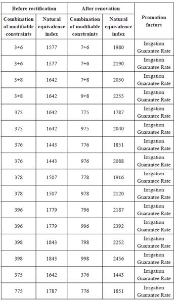
According to the results of supplementary improvement of cultivated land quality in 2010 in the high-tech zone, the cultivated land quality grading factors in the zone include irrigation assurance rate, surface soil texture, soil organic matter content, and profile configuration, with 4, 3, 5 and 7 grading levels respectively (Table 4), and three modifiable factors. Corresponding codes express the score of modifiable factors of the agricultural land grading unit. The factor scores (10-100 points) correspond to 10 codes of 1, 2, 3, 4, 5, 6, 7, 8, 9 and + respectively. The three factors' score codes are combined according to the order of grading factors in Table 4 to be the combination type identification of modifiable factors of natural quality assessment unit. For example, if the combination type of modifiable factors in an evaluation unit is marked as "398", it means that the irrigation assurance rate score of the unit is 30 points, corresponding to no irrigation conditions; the texture score of the surface soil is 90 points, corresponding to the surface soil is mainly clay; the quality score of the soil organic matter is 80 points, and the quality score of the corresponding organic matter is more than 2%. By analogy, all combination types of three factors of all evaluation units are obtained.

Combination of limiting factors
Because crop growth depends on the satisfaction degree of the living environment to its optimal growth environment factor value (marked by factor score in this paper), the small satisfaction degree is the main limiting factor affecting crop growth; and the main reason concerning the production capacity of agricultural land. The first limiting factor, i.e., the largest limiting factor, is the least satisfied, followed by the second limiting factor, and so on. According to this principle and grading standard, when the grading factor's score is 50 or below, the factor will have a major limiting effect on crop growth. If the content of soil organic matter is less than 0.6% (i.e., the score of organic matter is 20), it is poor in nutrients; the texture of surface soil is gravelly soil, the salinization of soil above heavy level and the condition of no irrigation and drainage have seriously affected the cultivation of agricultural land. Therefore, the factor scores between 10 and 50 (the identification code is 1, 2, 3, 4, and 5) are regarded as the limiting factors. The combination containing the limiting factors is selected from this combination of the modifiable factors to determine the type of the combination of the modifiable limiting factors, as the research object.
Calculation of natural quality potential
According to the light and temperature production potential index and yield ratio coefficient of each designated crop, combined with the grading factor weight and factor index score of the selected crop, calculate the natural quality index before remediation following the regulations. Then, combined with the study area's actual situation, the qualitative and quantitative methods such as GIS and remote sensing are comprehensively used to analyze the factors that can be transformed, and the degree of transformation. After remediation, the natural quality of cultivated land after remediation is reevaluated to obtain the index of natural quality. Finally, the potential of the natural quality of cultivated land remediation is obtained according to the difference of natural index before and after remediation. The calculation formula is as follows:

Among them, K is the number of grading factors; s is the number of designated crops; r is the number of grading factors; w k . is the weight of the k grading factors; β j is the yield ratio coefficient of the j crop; a tj is the light and temperature production potential index of the j crop; f k and f’k are the index scores corresponding to the modifiable limiting factors before and after the treatment; R ij , R’ ij and R i respectively represent the natural quality indexes and potential of the j crops before and after treatment.
Results
Data preprocessing
Taking Baoding National High-tech Development Zone as the research area, 400mx400m grid division is adopted. Through the fishnet tool in ArcGIS software, the grid is created. After spatial connection and spatial superposition, the spatial relationship between the grid and multi-source data such as land resources, linear features is established to prepare for the grid computing of evaluation indexes. The research area is divided into 4338 grid units, as shown in Figure 1.

Evaluation results of land resource utilization potential of Baoding hightech zone
According to the data of Baoding Statistical Yearbook (2014-2018) and Statistics Bureau of high-tech Zone (2014-2018), combined with the evaluation model, the land sustainable utilization degree of the high-tech zone in 20142018 was calculated by levels, and the evaluation results are shown in Table 5. On this basis, Figure 2 was obtained.


In conclusion, the evaluation results of sustainable land use in the hightech zone are as follows: ①the rationality of land use in the area is relatively high, and the index continues to rise during the evaluation period, from 0.48 in 2014 to 0.81 in 2018, which is at a sustainable high level. ②in terms of resource security, the high-tech zone score is low, there is no change during the evaluation period, and it is basically at a low level. The main reason for the low resource security index is that the per capita urban public green space area (0.12 m2/person), per capita cultivated land area (0.034684 HA/person), per capita grain occupation (300 kg/person), and other indexes are far from the national standard value. (③ although the economic feasibility index has moved from a lower level to a medium level, it fluctuates greatly. After reaching a high of 0.55 in 2016, it shows a downward trend in the following two years. ④ the social acceptability is more reasonable. During the evaluation period, the index moved from the lower to the middle and higher levels, but its fluctuation is too large. ⑤ comprehensively, in the past five years, the sustainable degree of land use in the high-tech zone has experienced a fluctuating process of rising first and then declining, but it is basically in the stage of medium sustainable development, with great potential for future improvement.
Potential measurement results
According to the calculation methods of expansion potential, intensity potential, structure potential, and years of land available, the current land resource potential data of Baoding National High-tech Development Zone can be obtained as follows: 712.96 hm2 of urban construction land has been built in the high-tech Development Zone, and 65.91 hm2 of land has been supplied but not yet built. Also, the area of non-construction land is 26.82 hm2. According to the calculation method of expansion potential, the available land in Baoding high-tech development zone is 256.16 hm2. Among them, according to the land use planning of high-tech development zone, 47.38 hm2 of land can be allocated, mainly for road, green space, public management, and public service; 208.78 hm2 for compensation, including 90.68 hm2 of land for industrial and mining storage; and 118.10 hm2 of another land can be used for compensation. According to the spatial distribution of the available land, it is mainly located in the third phase of the central area, the west area, and the experimental area, and all the land in the east area has been supplied. The completed industrial and mining storage land area in Baoding National High-tech Development Zone is 427.01 hm2; the current value of the comprehensive plot ratio of industrial land is 0.60, and the ideal value is 0.65. According to the formula, the land area for improving the comprehensive plot ratio of industrial land is 32.85 hm2; the current value of industrial land construction coefficient is 41.88%, the ideal value is 45%, and the area of potential land that can be tapped by increasing the building density of industrial land is 29.61 hm2. The current value of industrial land fixed asset input intensity is 57.3557 million yuan/hm2, the ideal value is 58.5 million yuan/hm2, the area of potential land that can be tapped by increasing the input intensity of industrial land fixed assets is 8.21 hm2; the current value of industrial land output intensity is 12271. 380000 yuan/hm2, the ideal value is 123000000 yuan/hm2, and the area of potential land to increase the output intensity of industrial land is 0.99 hm2; the constructed urban construction land in Baoding National High-tech Development Zone is 712.96 hm2, the current value of industrial land use rate is 59.89%, and the ideal value of industrial land use rate is 62%. According to the calculation method of expansion potential, through the adjustment of land structure, the area of industrial and mining storage land can be increased to 15.04 hm2; from 2016 to 2018, the average annual supply land of Baoding high-tech zone in the first three years is 28.50 hm2, and the yearly average supply land of industrial and mining storage in the first three years is 7.60 hm2, from which it can be calculated that the number of available land years I is 8.99; and the number of available industrial and mining storage years I is 11.94. Within the high-tech zone's evaluation scope, the maximum area of land supplied in the first five years is 74.28 hm2, and the maximum area of the land provided for industrial and mining storage in the first five years is 16.19 hm2. Therefore, it is calculated that the number of years of land available II is 3.44 years, and the number of years of land available for industrial and mining storage II is 5.60 years. Combined with the above analysis, Table 6 was made.
Table 6 Estimation of the number of years available for the expansion potential of Baoding national high-tech zone

Table 7 Summary of land-intensive utilization potential of Baoding national high-tech industrial development zone hm2

Based on the current land resource potential data of Baoding National High-tech Development Zone, the potential expansion calculation, potential strength calculation, potential structural calculation and available land year calculation, and the summary of land-intensive utilization potential were obtained, as shown in Table 7.
It can be seen from Table 7 that the structure potential of the high-tech zone is relatively small, and the area of industrial and mining storage land can be increased by structural adjustment to 15.05hm2, which further proves that the structure of the land in the high-tech zone has been relatively reasonable and conforms to the development orientation of the high-tech site; the area of industrial and mining storage land that can be explored by improving the comprehensive plot ratio of industrial land and the building density of industrial land is 32.86 and 29.62hm2, respectively. It shows that the industrial land intensity in the zone also has an absolute mining potential; the industrial input-output power of intensive land use in the high-tech area has a small mining potential. By increasing the input intensity of industrial land fixed assets and industrial land output, the land volume for industrial and mining storage can be increased by 8.21hm2 and 0.99hm2, respectively.
According to the calculation formula of expansion potential and Baoding high-tech zone's situation, the available land area of the evaluation scope is 256.16hm2, including 90.68hm2 of the available industrial and mining storage area. According to the calculation of the annual average supply land and the average yearly supply industrial and mining storage area of the previous three years, the actual available land number of Baoding high-tech zone is 8.99 years, and the available industrial and mining storage area is determined comprehensively. According to the maximum land supply in the first five years and the maximum land supply for industrial and mining storage, it was calculated that the number of years that the high-tech zone can supply is 3.44 years, and the land supply for industrial and mining storage is 5.60 years.
Natural quality potential
Combination of modifiable limiting factors
In theory, the combination type of modifiable factors of agricultural land classification unit in Baoding National High-tech Development Zone should be 60 kinds of combination of three factors at different levels. Through summary analysis, it is found that there are only 19 types of all factor combination of modifiable factors, among which eight types (3 + 6, 3 + 8, 375, 376, 378, 396, 398, 775) are qualified, and their distribution is shown in Figure 3.

It can be seen from Figure 3 that the distribution of the combinations of the restrictions on the removability of agricultural land in the high-tech zone is relatively scattered. Six of the eight combinations belong to the single restriction on the guaranteed rate of agricultural irrigation. One belongs to the single restriction on the content of soil organic matter (red area in the figure), and one belongs to the double restriction factors of "the guaranteed rate of irrigation + the content of soil organic matter." The double restriction factors are concentrated in Baizhigan town and Dongcheng Town. At the junction of Fangzhen, the area is relatively small (purple area in the picture). Therefore, it can be concluded that the natural conditions of the cultivated land in the hightech zone are mostly affected by the two limiting factors of irrigation guarantee rate and organic matter content. The irrigation guarantee rate is the leading limiting factor, and the whole area is affected by different degrees, so the land remediation project should focus on it.
Potential measurement and classification
Through the overlay analysis tool of ArcMap, the overlay comparison analysis between the layers of the modifiable limiting factor unit and the non-limiting factor unit shows that 90% of the cultivated land in Baizhigan Town, Dongchengfang Town, Shuangta Street, Yihezhuang are generally full, that is to say, the factor score code is 7. At the same time, the corresponding irrigation assurance rates of the other 11 towns are mostly basic. Satisfied, that is, the factor score code is 9, according to which, the score of limiting factors of irrigation assurance rate in the above four villages and towns is increased from code 3 to 7. That is, 1 level is increased, and 11 villages and towns such as Songlindian are increased from 3 to 9, that is, two levels are increased. The distribution of limiting factors of organic matter is relatively centralized, the area is relatively small, and the organic matter content of the surrounding cultivated land is higher than 20%; that is, 1 level is higher.
According to the calculation formula of natural quality potential, calculate the natural equivalent index and promotion potential of cultivated land in the whole area before and after the renovation. Table 8 showed the combination type and natural equivalent index of some factors before and after the promotion.
In Table 8, the average natural equivalency index changed from 13782521 to 1851-2521. And the natural equivalency index increased by 174 on average, that is, 0.87 provincial natural classes. The national natural index increased by 211 on average, that is, 0.53 national natural grades. According to the classification method of natural discontinuities, the results are shown in Figure 4.
In Figure 4, level 1 indicates the natural equal index's potential range is 0-90, level 2 is 90-275, and level 3 is 275-473. The high-value areas of the natural quality potential of land remediation in the high-tech zone are mainly distributed in the west, northeast, and small in the north and south. The towns involved are Dongchengfang Town, wharf Town, Yihezhuang Town, Dongxianpo Town, Diaoweo Town, Linjiatun town, and Haoguanzhuang town. In other areas, the promotion potential is relatively low and scattered, so it can be targeted to improve the old infrastructure such as irrigation and drainage, improve farmers' awareness of green planting, encourage the use of organic fertilizers, and other measures.

Conclusions
In this paper, the potential of land resource utilization in Baoding hightech Zone is evaluated by the method of the potential of land resource utilization based on the combination empowerment, and the potential of land intensive utilization is evaluated from the five aspects of the potential of expansion, structural potential and intensity potential of land resources in the high-tech zone. At the same time, the nature after renovation is obtained through the combination of the limited factors and the limited factors of land removability in the development zone. The analysis results show that from 2014 to 2018, the sustainable utilization index of land resources in Baoding high-tech zone is fluctuating on the whole, but it is basically in the stage of medium sustainable development, with great potential for future improvement. From 0.43 in 2014 to 0.51 in 2018, the overall land utilization is in the stage of medium sustainable utilization. However, land use status has the greatest impact on the level of sustainable land use, followed by social acceptability, resource security and economic feasibility. The main reasons that restrict the improvement of the level of sustainable utilization of land resources are economic feasibility, social acceptability and resource security. These indicators are still at a medium or low level, especially the resource security is at a low level of development. Therefore, in order to make a better sustainable use of land resources in the high-tech zone, the high-tech zone should start from the following aspects.
(1) Strengthen land consolidation and development and improve land use efficiency. Although the land use situation of the high-tech zone is good, in order to make more scientific and rational use of land, we must make efforts to improve the basic conditions of agricultural production, increase the intensity of land reclamation and consolidation, increase the effective cultivated land area, and improve the efficiency of land production.
(2) Improve the resource security of land use and realize the transformation to the sustainable development mode. The evaluation result of land resource security of high-tech zone is still at a low level, which is not consistent with the level of social and economic development, which requires that in the process of economic development, high-tech zone should pay attention to improving the number of public green space and cultivated land area.
(3) According to the regional characteristics, improve the level of economic development and social acceptability. Formulate reasonable development strategies, change the industrial structure, increase the proportion of the second and third industries, increase the disposable income of residents, improve the land utilization rate, and promote economic development. At the same time, we should continue to improve the per capita net income of farmers, increase investment in education, improve infrastructure, increase medical and health facilities and the number of doctors, so as to improve social satisfaction.

