


 English (pdf)
 Article in xml format
 Article references
 Send this article by e-mail
 Cited by SciELO
  Cited by Google
  Similars in
SciELO
Similars in
SciELO  Similars in Google
 Permalink
INTRODUCTION
A member of the family Arecaceae, subfamily Arecoideae, Geonoma is one of the three largest genera of palms in the Neotropical region, together with Bactris and Chamaedorea (Henderson 2011, Palmweb c2020). This genus comprises 68 species distributed from southern Mexico to south-western Brazil (Henderson 2011). It grows in the understory of tropical forests in plains or mountainous regions and has even been registered at altitudes of up to 3 000 m (Dransfield et al. 2008, Henderson 2011).
In Brazil, Geonoma is represented by 24 species (Henderson 2011), with widespread distribution in most states, except Paraíba, Piauí, Rio Grande do Norte, and Sergipe (Flora do Brasil c2020). The genus has a greater diversity of species in forest formations associated with the Amazon and Atlantic Biomes, but few representatives in open vegetation (Lorenzi et al. 2010). Nevertheless, Geonoma is sparely collected in the Eastern Amazon (Henderson 2011), a region that stands out due to the low density of samples and studies related to palms (Pintaud et al. 2008, Alvez-Valles et al. 2018). About the conservation status of the genus, data are still scarce, and most taxons of Geonoma that occur in Brazil have not been evaluated (Elias et al. 2019, Flora do Brasil c2020). This scenario in Brazil only reinforces that the measurement of the extinction risk to species has needed to be addressed more since these assessments are urgently needed to guide conservation practitioners on appropriate development and conservation measures planning and the guidance of essential research (Gardiner and Bachman 2016). Twenty-five years ago, the International Union for Conservation of Nature (IUCN) Palm Specialist Group (Johnson 1996) already urgently recommended that the researchers assess all palm species' conservation status. However, to date, few advances have been observed in this regard in the country.
According to Henderson (2011) and Flora do Brasil (c2020), in Maranhão, a Brazilian state located in a transition area between the Eastern Amazon, the Cerrado, and the Caatinga, there are only two species of Geonoma: G. baculifera (Poit.) Kunth and G. leptospadix Trail, both catalogued in the Amazon Forest. However, this information about the Geonoma richness in Maranhão is different from what was pointed out in other studies such as Lorenzi et al. (2010), whom also report G. pauciflora Mart. in Maranhão, as well as Pinheiro (2011), which declares that only G. baculifera occurs in the state. These divergences reinforce the existence of gaps in taxonomic knowledge in this transition region, what was already verified in a taxonomic survey carried out for other group of Arecaceae in the state (Lima and Almeida Jr 2020).
In view of the need for further studies to clarify and solve the disagreements regarding and gaps of the genus Geonoma in Maranhão, the present research aims to elaborate a taxonomic analysis of the species of the genus in the state. In this sense, this study presents taxonomic descriptions and an identification key for all recognized taxons, as well as a distribution map, photographic plates and preliminary conservation status assessments.
MATERIAL AND METHODS
The taxonomic treatment of the Geonoma in Maranhão state was based on samples at the following herbaria CEN, IAN, INPA, MAR, NY, SLUI, U, and UB, by visits to the collections or online consultations available on the platforms SpeciesLink (SpeciesLink c2021), Reflora Virtual Herbarium (Reflora c2021), and Naturalis Biodiversity Center (BioPortal c2021). All herbarium acronyms previously mentioned follow Thiers (c2020). In these collections, additional materials referring to other countries and Brazilian states were also analyzed. At the same time, sporadic field expeditions were carried out in 2016 and 2017 to the municipality of Cândido Mendes (oi°5i'23" South; 45°48'i9" West) in Amazon rainforest, and Mirador State Park (o6°37'26.4" South; 45°52'o8.8" West) in the Cerrado of the Maranhão state. The collected plants were herborized according to the usual botanical methodology (Martins and Filgueiras 2010) and deposited in the Maranhão herbarium (MAR).
Typus specimens and specialized literature were consulted to identify the samples (Lorenzi et al. 2010, Henderson 2011). The scientific names' spelling was verified in the databases Palmweb (c2020) and Tropicos (c2020). The description of the morphological characters was carried out following the terminologies available on Palmweb (c2020) and Henderson (2011). A taxonomic key was elaborated for the species of Geonoma occurring on the territory of Maranhão.
Photographic plates were assembled to allow better understanding of the distinctive characters between species. A distribution map was also generated through the Quantum GIS 3.4.5 program (QGIS Development Team c2020) using the WGS84 datum to show the distribution of the Geonoma species in the state.
Concerning the preliminary status of conservation of the species, criterion B proposed by the IUCN (2012) was used to estimate extinction risks. This criterion is the most widely used for estimating conservation status, due to its advantage of allowing assessments to be undertaken using distribution data only, which are in many cases the only information available (Schatz 2002, Gaston and Fuller 2009, Dauby et al. 2017). The Extent of Occurrence (EOO), Area of Occupancy (AOO), and number of locations, which are parameters for this evaluation, were calculated using the ConR package (Dauby et al. 2017) implemented in the R software version 3.5.0 (R Development Core Team c2020). The EOO was estimated from a convex hull plotted to include all known points of the species. Areas of entirely unsuitable environment (such areas of the Atlantic Ocean) were excluded in the EOO. The AOO was estimated using the 2x2 km grids (4 km2), as recommended by IUCN (2019). The number of locations were estimated with a 10 km grid resolution. About the distribution data, we used the georeferenced specimens listed by Henderson (2011), which is the most updated revision of the group and has an extensive available database. On the other hand, we also obtained occurrence points from consulted herbarium and our field trips. When coordinates of collecting localities were not available in these new samples of the herbarium, they were estimated using Google Maps (Google c2021) and the geoLoc tool of the Species-Link (SpeciesLink c2021). Doubtful records of occurrence were excluded, and in the case of duplicated occurrence records, only one of the records was used in the analyses.
RESULTS AND DISCUSSION
A total of five species of Geonoma were identified for the Maranhão state: G. baculifera (Poit.) Kunth, G. leptospa-dix Trail, G. maxima (Poit.) Kunth subsp. maxima, G. pohliana subsp. weddelliana (H. Wendl.) A.J. Hend., and G. poiteauana Kunth. The species G. baculifera and G. leptospadix were already cited with occurrence for Maranhão (Lorenzi et al. 2010, Henderson 2011, Pinheiro 2011, Flora do Brasil c2020). However, G. maxima subsp. maxima, G. pohliana subsp. weddelliana and G. poiteauana are new occurrence records. According to Lorenzi et al. (2010), G. pauciflora Mart. is another palm of this genus that also occurs in Maranhão. However, no voucher plant materials were observed in herbaria for this species. As reported by Henderson (2011), this taxon is endemic of the Atlantic Forest of Brazil from Pernambuco to Bahia states.
Based on the latest phylogenetic study (Loiseau et al. 2019), each one of five species now known to Maranhão is circumscribed in a different clade: G. maxima subsp. maxima to Clade I, G. baculifera to Clade II, G. poiteauana to Clade III, G. leptospadix to Clade V, and G. pohliana subsp. weddelliana to Clade VII. According to Loiseau et al. (2019), except for G. leptospadix and G. baculifera, all other palms are not considered monophyletic based on the molecular data. Nevertheless, the authors also pointed out that new taxonomic classifications based on their results to the non-monophyletic species would require a full assessment of population genetics, morphological, and ecological evidence, which currently are still insufficient; therefore they abstained from proposing new classifications. For this reason, we continue using the species delimitations recognized by Henderson (2011) in our study, which emphasize morphological similarities and the ability to diagnose the taxa.
Taxonomic treatment
Geonoma Willd., Sp. Pl. 4: 174 (1805).
Lectotype designated by Moore (1963): Geonoma simplicifrons Willd.
Palm stems solitary or clustered, unarmed, pleonanthic, monoecious. Stem very short to medium size, underground, prostrate or aerial, slender, smooth, glabrous or covered with reddish or brownish scales, usually with conspicuous nodes. Leaf blade entire, bifid or pinnate (regularly or irregularly), not plicate or plicate; sheath open, splitting opposite the petiole; petiole short or long; rachis absent, short or long. Inflorescence intrafoliar or interfoliar, unbranched or branched up to fourth order; peduncle very short to long, glabrous or tomentose; prophyll unique, tubular, narrow, short or elongate, usually closely sheathing the peduncle, glabrous or variously tomentose, deciduous or persistent; peduncular bract present, rarely vestigial or absent, deciduous or persistent, often very similar to the prophyll; rachilla short to medium, filiform or not filiform, spiky surfaces with fibrous projections, or with faint to pronounced, short, transverse ridges; flowers arranged in triads borne in pits in the rachilla; flower pits spirally, alternately, tricussately or decussately arranged throughout the rachilla, pit without upper lip or upper lip distinct, glabrous or variously hairy internally; floral bracteoles 3, irregular, membranous. Staminate flower deciduous or persistent after anthesis; sepals 3, free, imbricate; petals 3, connate proximally for about half their length into a tube, free and valvate distally; stamens 3, 6 or rarely more, filaments united into a tube proximally and free distally, thecae inserted almost directly onto the filament apices, connective and anther with different forms; pistil-lode small or well-developed. Pistillate flower deciduous or persistent after anthesis; sepals and petals similar in number and form to those of the staminate flower; staminodes present and united in a tube, apex of the tube with different forms. Gynoecium tricarpellate but only one carpel develops, unilocular, uniovulate; style basally inserted, elongate, exerted above the mouth of the staminodial tube. Fruit globose to ellipsoid, purple black, sometimes blue or reddish, base of the fruit with a prominent stipe or without a prominent stipe; epicarp smooth or bumpy with the numerous fibers, splitting or not at maturity; mesocarp with dense layer of fibers or without fibers; endocarp thin; seed 1, without pores, few pores or with numerous pores.
Taxonomic key to Geonoma species in Maranhão state, Brazil
1. Occurs in the understory of gallery forests of the Cerrado; flower pits usually decussately arranged throughout
the inflorescence..................................................................
..........................d. Geonoma pohliana subsp. weddelliana
1'. Occurs in the understory of the forests of the Amazon region; flower pits usually spirally arranged throughout the inflorescence
2. Inflorescence unbranched.........e. Geonoma poiteauana
2'. Inflorescence branched
3. Leaf blade regularly pinnate............................................
.................................c. Geonoma maxima subsp. maxima
3'. Leaf blade entire, bifid or irregularly pinnate
4. Prophyll 15.4-32 cm long; rachillae with diameter > 2.5 mm; flower pits closely spaced on the inflorescence; fruit ovoid to ellipsoid.............................a. Geonoma baculifera
4'. Prophyll 6-10.4 cm long; rachillae with diameter < 1.7 mm; flower pits not closely spaced on the inflorescence; fruit globose..................................b. Geonoma leptospadix
. Geonoma baculifera (Poit.) Kunth, Enum. Pl. 3: 233. 1841. Fig. 1a-b.
Palm 1-6 m tall, caulescent, solitary or clustered. Stem 1.5-2.3 cm in diameter; internode 1.4-7 cm long, yellowish and smooth. Leafs 6-11 per stem, bifid or irregularly pinnate, not plicate; sheath 11-21.5 cm long; petiole 6.525 cm long; leaf rachis 42-80 cm long; leaf bifid 59.8108.5 cm long; pinnae 2-10 per side of rachis; basal pinna 45-70 X 6.7-26.5 cm; apical pinna 25-32.5 x 17-22 cm. Inflorescence branched in 1 or rarely 2 orders; prophyll 15.4-32 cm long; peduncular bract not seen; peduncle 1239.5 cm long; rachillae 4-11, 7.5-31 cm long and 2.6-4 mm in diameter, not filiform; flower pits spirally arranged and closely spaced on the inflorescence. Fruit 8-12.8 x 6-8.3 mm, ovoid to ellipsoid, black at maturity.
Geographic distribution. G. baculifera occurs in tropical lowland forests of Amazon region of Brazil (Amapá, Amazonas, Maranhão, Pará, Rondônia, and Roraima), as well as the Guianas and Venezuela (Henderson 2011). In Maranhão, this species was found in fragments of the Amazonian forest in the northwest region (Fig. 2), with specimens mainly in the Alto Turiacu Indigenous Land.
Conservation status. A total of 96 specimens were compiled for G. baculifera, collected in 88 different locations (Henderson 2011), which gave to this taxon an extent of occurrence (EOO) of 2 721 850 km2 and an area of occupancy (AOO) estimated at 368 km2. Due to its wide presence in Amazon, commonly found in relatively intact forests and protected areas, G. baculifera is classified as Least Concern (LC) in the present study. This classification agrees with the rating of Loftus (c2013), in which this species is considered as Least Concern (LC). However, as Loftus (c2013), we also highlight that this palm should be carefully monitored due to threats such as habitat loss, mainly in Maranhão state.
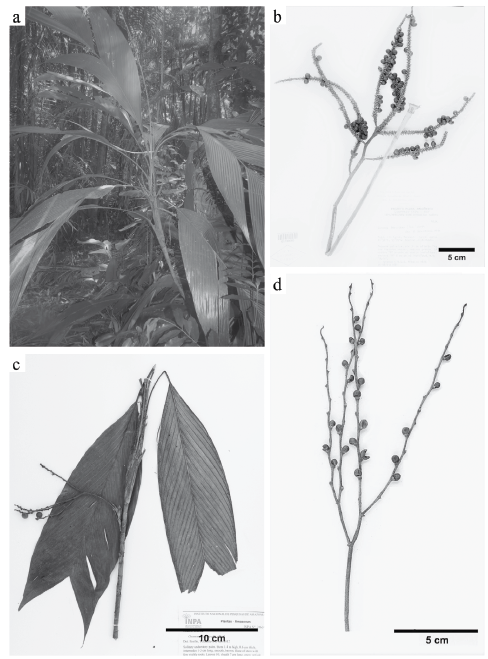
Figure 1 Leafs and inflorescences of the Geonoma species investigated; a-b. Geonoma baculifera; a. Palm tree with irregular leafs in its natural environment (G.R Lima et al. 666); b. Branched inflorescence in the first order with flower pits closely spaced on the rachillae (J. Jangoux & B.G.S. Ribeiro 1615). and c-d. Geonoma leptospadix; c. Specimen with bifid leafs (T. Emilio et al. 815); d. Branched inflorescence in the first order with flower pits not closely spaced on the rachillae (W. Balée & B. Ribeiro 2965). Photographs by G.P. Lima.
Material examined. BRAZIL. Maranhão: Cândido Mendes, Sete Irmãos Farm, 01°51'13" South, 45°46'13.2" West, 04 nov 2017, G.P. Lima et al. 666 (MAR); P.I. Guajá, Rio Turiaçu, Guajá Indians, 03°07' South, 46°05' West, 17 jun 1987, W. Baleé 3347 (NY); Rio Gurupi, 13 mar 1958, R.L. Fróes 34209 (IAN); Urutawy, Ka'apor Indian Reserve, basin of Rio Turiaçu, 10 km from village, 5 oct 1986, W. Baleé 2675 (NY).
Additional material examined. BRAZIL. Amapá: First waterfall on Rio Iaué, 0.5 km E of confluence with Rio Oiapoque, 02°53' North, 52°22' West, 22 aug 1960, H.S. Irwin & L.Y.T. Westra 47714 (NY); Macapá, Rio Matapi, entre a estrada e a foz do rio, 04 mar 1983, B.V. Rabelo et al. 1861 (NY). Amazonas: Maraã, Rio Japurá, Lago Maraã, 01°51' South, 65°36' West, 4-5 dec 1982, T. Plowman et al. 12235 (NY). Pará: 1-2 km of Repartimento, ca. 140 km on the road Marabá-Altamira, 24 oct 1977, C.C. Berg et al. 699 (NY); 25-35 km of Tucuruí, 03°56' South, 49°49' West, 4 nov 1981, D.C. Daly et al. 1213 (NY); Anajás, Caxinguba, Rio Moções, ca. 45 minutes below mouth of Igarapé Francês, 30 oct 1984, J. Strudwick et al. 5007 (NY); Basin of the Rio Gurupi, Tembé Indian Reserve, 6km SSW of FUNAI Post Canindé, 8 aug 1985, W. Baleé & B.G. Ribeiro 1549 (NY); Rio Caruá, Pacoval, 01°50' South, 55°05' West, 06-08 aug 1981, J. Jangoux & B.G.S. Ribeiro 1615 (NY); Rio Ora, Maje do Guama, 12 mar 1968, C.F. Sastre 115 (NY); Rios Pacajá and Muira-piranga, 0-5 km S of Rio Muirapiranga, 10 oct 1965, G.T. Prance et al. 1598 (NY); Road Campanema to Maranhão, km 107, 20 km W of Rio Gurupi, 26 oct 1965, G.T. Prance & T.D. Pennington 1675 (NY); Tracuateua, 01°05' South, 46°55' West, 18 nov 1981, M.J. Balick et al. 1303 (NY); Tucuruí, 25 km S of Represa Tucuruí on road (BR-422) to Breu Branco, 03°52' South, 49°44' West, 90 m, 15 mar 1980, T. Plowman et al. 9586 (NY); Tucuruí, 30 aug 1983, J. Revilla et al. 8376 (NY). Roraima: SEMA Ecological Reserve, Ilha de Maracá, 03°29' North, 61°46' West, 20 jul 1987, W. Milliken et al. 460 (NY); Serra da Lua, 10 km SE of Serra da Lua, 03°25-29' North, 60°11-14' West, 20 jan 1969, G.T. Prance et al. 9362 (NY). FRENCH GUYANA. Arrondissement of Cayenne: road to Mont Inéri, Ap-prouague River, 04°21' North, 52°09' West, 10 m, 8 sep 1997, G. Cremers et al. 15318 (NY). GUAYANA. Upper Takutu-Upper Esequibo: Acarai Mountains, Watuwau Creek, 6-10 km upstream of juncture with Chodikar River, 01°22' North, 58°42' West, 250 m, 23 feb 1994, T.W. Henkel et al. 4701 (NY); Basin of Essequibo River, near mouth of Onoro Creek, 15-24 dec 1937, A.C. Smith 2770 (NY); Kuyuwini River, trail to Kassikaityu River, 0-1 km S of camp at Anteater Head Creek, 01°55' North, 59°06' West, 260 m, 16 may 1997, D. Clarke 4584 (NY); Rewa River, 0-2 km S of camp, 02°59' North, 58°35' West, 150 m, 21 feb 1997, D. Clarke 3776 (NY). Barima-Waini: Kariako village, Barama River, 07°22' North, 59°42' West, 16 dec 1995, T. van Andel et al. 633 (U). SURINAME. Sipaliwini: Nature Reserve Voltz Berg, Coppename River, near Raleigh falls, on Foengoe Island in forest, 26 feb 1977, J.C. Lindeman et al. 167 (U). VENEZUELA. Amazonas: La Esmeralda, Upper Orinoco, 1 km upriver, right bank, 24 may 1994, C. Listabarth 12-240594 (NY); Mavaca, Alto Orinoco, Indios Guaicas (Yanomanö), jan 1970, L. Aris-teguieta & J. Lizot 7415 (NY).
b. Geonoma leptospadix Trail, J. Bot. 14: 327. 1876. Fig. 1c-d.
Palm 0.5-2 m tall, caulescent, solitary or clustered. Stem 0.7-1.0 cm in diameter; internode 0.8-1.0 cm long, yellowish and smooth. Leafs 8-17 per stem, bifid, not plicate; sheath 8.5-9.5 cm long; petiole 3.5-13 cm long; leaf rachis 25-42 cm long; leaf bifid 34-55.8 cm long. Inflorescence branched in 1 order; prophyll 6-10.4 cm long; peduncular bract not seen; peduncle 11.5-15 cm long; rachillae 3-5, 7-19.7 cm long and 0.9-1.7 mm in diameter, not filiform; flower pits spirally arranged and not closely spaced on the inflorescence. Fruit 7.3-8.1 x 6.8-7.7 mm, globose, black at maturity.
Geographic distribution. This species occurs in the Amazon lowland rainforest. In Bolivia, Peru, Ecuador, Colombia, Venezuela, Guyana, Suriname, French Guiana, and Brazil (Acre, Amapá, Maranhão, Rondônia, and Roraima) (Henderson 2011). In Maranhão, the only specimen observed to date was collected in the 1980s, within the boundaries of the Alto Turiacu Indigenous Land (Fig. 2).
Conservation status. A total of 54 specimens were compiled from 51 locations (Henderson 2011), which gave to G. leptospadix an extent of occurrence (EOO) of 4 618 043 km2 and a restricted area of occupancy (AOO), estimated of 208 km2. Due to its wide distribution in relatively intact forests, besides its occurrence in several protected areas in Amazon, this taxon is classified initially as Least Concern (LC). However, new research is necessary for Maranhão so that its geographic occurrence can be adequately documented since the only known record dates back to the 1980s, when the Amazon Forest still predominated in the state landscape (Celentano et al. 2017).
Material examined. BRAZIL. Maranhão: Carutapera, Gurupiuna, Ka'apor Indian Reserve, affluent of Rio Gurupi, 02°43' South, 46°26' West, 6 nov 1986, W. Balée & B. Ribeiro 2965 (NY).
Additional material examined. BRAZIL. Amazonas: Altamira, right bank of Rio Juruá, 06°35' South, 68°54' West, 14 nov 1991, R. Pardini 63 (NY); Alvarães, Lago Tefé opposite Tefé, 03°20' South, 64°50' West, 15 jan 1991, A. Henderson et al. 1553 (NY); Atalaia do Norte, Rio Curuçá, tributary of Javari, frontier between Brazil and Peru, 04°30' South, 71°22' West, 150 m, 12 jan 1989, A. Henderson et al. 877 (CEN); BR-319, Porto Velho-Manaus, 85 km N of Humaitá, Bonfuturo, 07°10' South, 63°00' West, 8 apr 1985, A. Henderson et al. 200 (NY); Estrada Manaus-Ca-racaraí, BR-174 (km 97), ramal que dá acesso ao canteiro de obra da Hidrelétrica de Balbina, 100 m da margem da estrada, 8 aug 1979, C.A. Cid et al. 7 (NY); Maraã, Rio Japurá, ca. 5 km W of Maraã, 11 jan 1991, A. Henderson et al. 1538 (CEN); Maraã, Rio Japurá, environs of town of Maraã, Lago Maraã, 01°51' South, 65°36' West, 4-5 dec 1982, T. Plowman et al. 12236 (NY); Maraã, left bank of Rio Japurá, 02°20' South, 65°10' West, 9 jan 1991, A. Henderson et al. 1521 (CEN); Rio Cunhã at Deni Indian village, 06°43' South, 66°47' West, 28 nov 1971, G.T. Prance et al. 16491 (NY); Rio Juruá, 260 km SW of Carauari, 137 km E of Eirunepé and 2.1 km N of Cubiu, 15 apr 2012, T. Emilio et al. 815 (NY). Rondônia: Porto Velho, 4 km E of Córrego Raiz on BR-364, 24 km ENE of junction with BR-325, 26 km (by air) E of Abunã, 09°43' South, 65°08' West, 140 m, 18 apr 1987, M. Nee 34903 (NY). Roraima: Serra dos Surucucus, S of Mission station, 02°42-47' North, 63°33-36' West, 18 feb 1969, G.T. Prance et al. 10036 (NY).
c. Geonoma maxima (Poit.) Kunth subsp. maxima, Enum. Pl. 3: 229. 1841. Fig. 3a-c.
Palm 1.5-6 m tall, caulescent, solitary or clustered. Stem 1.2-2.5 cm in diameter; internode 1.1-10 cm long, yellowish. Leafs 7-13 per stem, regularly pinnate, not plicate; sheath 13-16 cm long; petiole 30-51 cm long; leaf rachis 75-120 cm long; pinnae 15-31 per side of rachis; basal pinna 25-41 x 0.2-1.8 cm; apical pinna 16.5-28.5 x 0.76.7 cm. Inflorescence branched in 2-3 orders (rarely 1); prophyll 7.5-17 cm long; peduncular bract ca. 8.3 cm long; peduncle 5-10 cm long; rachillae 9-50, 6-17.5 cm long and 2-2.5 mm in diameter, not filiform; flower pits usually spirally arranged on the inflorescence. Fruit 7.9-11.3 x 6-8.1 mm, globose to ellipsoid, purple-black at maturity.
Geographic distribution. G. maxima subsp. maxima is distributed in tropical lowland forests of Central and Eastern Amazonia (Amazonas, Pará, and Amapá), as well as of the Guyana, Suriname, and French Guiana (Henderson 2011). After this research, the area of occurrence is extended to the northwestern part of Maranhão in a remnant fragment of the Amazon Forest within the boundaries of the municipality of Cândido Mendes (Fig. 2).
Conservation status. A total of 41 specimens were compiled for G. maxima subsp. maxima, collected in 34 different locations (Henderson 2011), which gave to this taxon an extent of occurrence (EOO) of 1 132 364 km2 and an area of occupancy (AOO) estimated at 140 km2. Due to its wide distribution in relatively intact forests, in addition to its existence in protected areas, G. maxima subsp. maxima is classified as Least Concern (LC) in the present study. However, threats such as loss of habitat due to logging and agricultural expansion should be carefully monitored, especially in the Maranhão state, which is located within the "Arc of Deforestation" in the Brazilian Amazon and where the remaining vegetation cover of this biome represents only 25 % of the territory (Celentano et al. 2017).
Material examined. BRAZIL. Maranhão: Cândido Mendes, Sete Irmãos Farm, 01°51'50" South, 45°46'02.3" West, 10 oct 2016, A. Ferreira 1 (MAR).
Additional material examined. BRAZIL. Amapá: road between Calçoene and Oiapoque (BR-156), 87 km NW of Calçoene, 02°49' North, 51°23' West, 07 dec 1984, S. Mori & R. Souza 17265 (NY); Island of Escondido, near mouth of Cricu River, 03°43' North, 51°55' West, 12 aug 1960, H. Irwin et al. 47455 (NY). Amazonas: Manaus, 60 km N of city on road to Caracaraí, then 3 km E on ZF1, 05 aug 1986, A. Henderson & J. Nascimento 649 (NY); Manaus, Adolfo Ducke Forest Reserve, on Manaus-Ita-coatiara road, 09 sep 1966, G.T. Prance et al. 2239 (NY); ibidem, 15 mar 1967, H. Moore et al. 9534 (INPA, NY); ibidem, 10-21 oct 1986, A. Henderson 664 (NY); Rio Preto da Eva, BDFF Reserve km 41, 64 km N of Manaus on BR-174 and then 41 km E on ZF-3, 29 aug 1989, A. Henderson et al. 1055 (CEN, NY). Pará: Anajás, opposite town of Anajás on Rio Anajás, 31 oct 1984, J. Strudwick et al. 5009 (NY); Basin of Rio Xingu, Gleba Bacajá, lote 88, just below mouth of Rio Bacajá, 03°22'20 South, 50°47'50 West, 28 nov 1980, G. T. Prance et al. P26519 (NY); Marabá, 24 may 1982, R. Secco et al. 304 (NY); Sebastião da Boa Vista, Sítio Campina, 20 oct 1984, J. Strudwick et al. 4671 (NY); Serra dos Carajás, ca. 10 km E of Itacaiúnas River and 4 km S on secondary road, 05°58' South, 50°25' West, 17 jun 1982, C. Sperling et al. 6210 (NY); Viseu, Tembé Indian Reserve, 6 km SSW of FUNAI Post Canindé, 17 aug 1985, W. Balée & B. Ribeiro 1591 (NY).
d. Geonoma pohliana subsp. weddelliana (H. Wendl.) A.J. Hend., Phytotaxa. 17: 130-131, f. 35. 2011. Fig. 3d-e.
Palm 1.5-5 m tall, caulescent, solitary or clustered. Stem 1-2.2 cm in diameter; internode 0.7-1.1 cm long, yellowish. Leafs 8-13 per stem, irregularly pinnate, not plicate; sheath 9.5-21.5 cm long; petiole 4.5-52.5 cm long; leaf rachis 16.8-59.5 cm long; pinnae 4-42 per side of rachis, spreading in the same plane; basal pinna 9.3-48.5 x 0.35.8 cm; apical pinna 8.6-30 x 0.3-17.5 cm. Inflorescence branched in 1-2 orders; prophyll 6-25.3 cm long, ridged and tomentose surface; peduncular bract 5.5-19.5 cm long; peduncle 8-33.5 cm long; rachillae 7-24, 14.5-31 cm long and 1.2-2.2 mm in diameter, not filiform; flower pits usually decussately arranged throughout the inflorescence. Fruit 7.9-10 x 5.1-7.8 mm, globose to ellipsoid, black at maturity.
Geographic distribution. This species is usually found in gallery forests, a physiognomy associated to the Cerrado. It is present in a significant part of the Brazilian Plateau (Bahia, Federal District, Goiás, Mato Grosso, Mato Grosso do Sul, Minas Gerais, Pará, Pernambuco, São Paulo, and Tocantins) and also occurs in Bolivia and Paraguay (Henderson 2011). Its presence in the state of Maranhão is confirmed for the first time at the Mirador State Park (municipality of Mirador), in the riparian forest bordering the Alpercata River, one of the main tributaries to the Itapecuru River, as well as within the boundaries of the municipality of Carolina (Fig. 2).
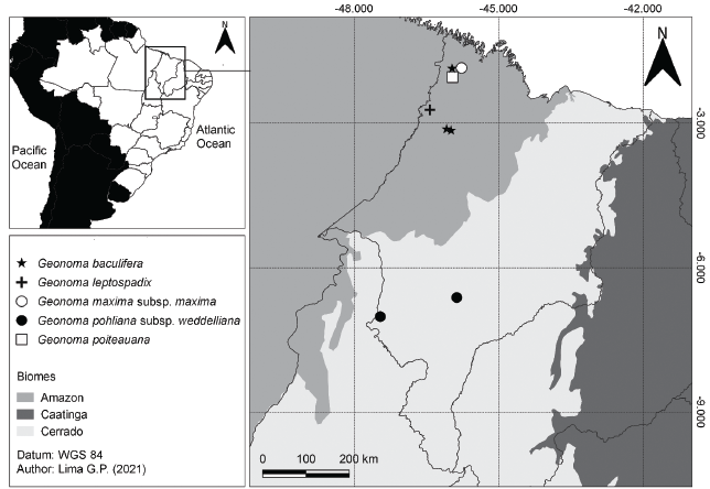
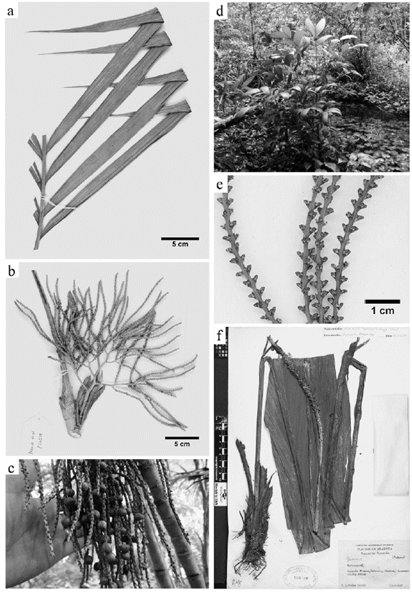
Figure 3 Morphological characters of the Geonoma species investigated; a-c. Geonoma maxima subsp. maxima; a. Pinnae regularly distributed on the leaf rachis (A. Henderson & J. Nascimento 649); b. Branched inflorescence in the second order (G.T Prance et al. P26519); c. Fruits at maturity (A. Ferreira 1). d-e. Geonoma pohliana subsp. weddelliana; d. Palm tree in its natural environment (A. Ferreira 2); e. Flower pits decussately arranged throughout the rachillae (H. Irwin et al. 19233). f. Geonoma poiteauana - specimen (R. Fróes 34499). Photographs by G.P. Lima and A.W.C. Ferreira.
Conservation status. G. pohliana subsp. weddelliana presented a broad EOO of 3 355 615 km2 and an AOO of 264 km2, as for the 87 specimens compiled, registered in 57 different locations (Henderson 2011). Due to its extensive distribution on the Brazilian Plateau, in addition to its existence within several conservation units and to the fact that it occurs mainly in gallery forests, which are theoretically Permanent Preservation Areas (PPAs) according to the Brazilian Forest Code (Law no. 12 651), the species is classified in the present study as Least Concern (LC).
Material examined. BRAZIL. Maranhão: Carolina, estrada vicinal para o povoado Brejinho, 07°01'02" South, 47°27'27" West, 180 m, 21 nov 2009, G. Pereira-Silva et al. 14703 (CEN); Mirador, Mirador State Park, source of the Alpercata River, 28 nov 1988, F. Noberto 220 (SLUI); Mirador, Mirador State Park, source of the Alpercata River, 06°37'17.9" South, 45°52'16.1" West, 14 feb 2017, A. Ferreira 2 (MAR).
Additional material examined. BRAZIL. Distrito Federal: Brasília, Fundação Zoobotânica, 18 aug 1961, E. Heringer 8589/783 (NY, UB); Brasília, ca. 25 km E of Brasília, 700-1000 m, 23 aug 1964, H. Irwin & T. Soder-strom 5422 (NY); Brasília, ca. 10 km E of Brasília, near So-bradinho, 01 oct 1965, H. Irwin et al. 8851 (NY); Brasília, APA de Cafuringa, Nascente do Rio do Sal, Fazenda Mac-namara, 21 aug 1998, R. Martins 211 (UB); Chapada da Contagem, ca. 20 km E of Brasília, 700-1000 m, 19 sep 1964, H. Irwin & T. Soderstrom 6276 (NY, UB); Chapada da Contagem, ca. 15 km NE of Brasília, 1000 m, 04 may 1966, H. Irwin et al. 15633 (NY, UB). Goiás: Chapada dos Veadeiros, ca. 20 km W. of Alto Paraíso de Goiás (formerly Veadeiros), 14° South, 47° West, 1000 m, 10 feb 1966, H. Irwin et al. 12479 (NY, UB); Chapada dos Veadeiros, ca. 10 km S of of Alto Paraíso de Goiás (formerly Veadeiros), 1000 m, 21 mar 1969, H. Irwin et al. 24838 (NY, UB); Chapada dos Veadeiros, ca. 14 km by road N of Alto Paraíso de Goiás, 04 mar 1973, W. Anderson 6289 (NY, UB); Serra dos Cristais, 2 km E by road of Cristalina, 1200 m, 04 apr 1973, W. Anderson 8138 (NY, UB); Serra dos Pireneus, 20 km NW of Corumbá de Goiás, 1250 m, 26 jan 1968, H. Irwin et al. 19233 (NY, UB). Pará: Itaituba, Estrada Satarém-Cuiabá (BR-163) - km 794, Serra do Cachimbo, Aeroporto do Cachimbo com penetração de 8 km dentro da mata, margem do Rio Formiga, 27 apr 1983, I. Amaral et al. 1015 (NY); Marabá, Serra dos Carajás, 20 mar 1984, A. Silva et al. 1937 (NY). Mato Grosso: 1 km E of km 264, Xavantina-Cachimbo road, 12°49' South, 51°46' West, 21 mar 1968, D. Philcox & A. Ferreira 4606 (NY). Mato Grosso do Sul: Luciara, distrito de Porto Alegre, ca. 1011 km da BR-158, 11°10' South, 51°40' West, 16 oct 1985, J. Pirani 1258 (NY); Rio Brilhante, Rio Sta. Luzia, 06 feb 1975, Hatschbach et al. 35907 (NY). Minas Gerais: São Roque de Minas, Parque Nacional da Serra da Canastra, Jaguaré (Jaguari), 1350 m, 30 sep 1999, R. Mello-Silva et al. 1667 (NY). Tocantins: Aguiarnópolis, Posto Indígena São José (FUNAI Reservation-Apinajé Tribe), ca. 20 km W of Tocantinópolis, 06°30' South, 47°30' West, 09 sep 1983, M. Balick et al. 1587 (CEN, NY).
e. Geonoma poiteauana Kunth, Enum. Pl. 3: 233. 1841. Fig. 3f.
Palm 1-2 m tall, acaulescent, solitary. Leaf blade bifid or irregularly pinnate, not plicate; sheath 12-17 cm long; petiole 18-20 cm long; leaf bifid 71.5-98.5 cm long; leaf irregularly pinnate with rachis 45.5-63.5 cm long and 2-3 pinnae per side of rachis; basal pinna 42-64 x 9-21 cm; apical pinna 37-38 x 13-14.5 cm. Inflorescence un-branched (spicate); prophyll 9-13.2 cm long, tubular; peduncular bract 16-23 cm long, tubular; peduncle 47.5-82 cm long; inflorescence axis 7.5-20 x 0.3-0.6 cm, orange at maturity; flower pits usually spirally arranged on the inflorescence. Fruit 8.7-8.1 x 7.1-6.5 mm, globose to ellipsoid, purple-black at maturity.
Geographic distribution. This species occurs in the Amazon lowland rainforest. It is found in Colombia, Venezuela, Guyana, Suriname, French Guiana, and Brazil (Amazonas, Pará, and Amapá) (Henderson 2011). After this study, the area of occurrence is extended to the northwestern part of Maranhão, with a sample collected near the Maracaçumé River, within the boundaries of the municipality of Maracaçumé (Fig. 2).
Conservation status. A total of 29 specimens were compiled from 28 locations (Henderson 2011), which gave to this taxon an extent of occurrence (EOO) of 2 330 834 km2 and a restricted area of occupancy (AOO), estimated at 116 km2. Due to its wide distribution in relatively intact forests, besides its occurrence in several protected areas, mainly in Guianas, G. poiteauana is classified initially as Least Concern (LC). However, it should be highlighted that the records of G. poiteauana on the Brazilian territory are still scarce, discontinuous, and old. It is represented in only nine locations, which demonstrates the need for new research to elucidate the current aspects of its geographic occurrence in the country. An example of this scenario is the distribution of this taxon in Maranhão, since the "new record" pointed out in the present article dates back to the 1950s, when the Amazon Forest still predominated in the state landscape (Celentano et al. 2017).
Material examined. BRAZIL. Maranhão: Maracaçumé, 17 jul 1958, R. Fróes 34499 (IAN).
Additional material examined. BRAZIL. Amapá: Macapá, Riozinho, 122 km NW of Porto Grande on the highway BR-210, 01°21' North, 53°15' West, 01 jan 1985, S. Mori & R. Souza 17611 (NY); Oiapoque, first cachoeira on Rio Iaué, 0.5 km E of confluence with Rio Oiapo-que, 02°53' North, 52°22' West, 22 aug 1960, H. Irwin & L. Westra 47707 (NY); Rio Araguari, between Cachoeiras Travessão and Santa Maria, 01°09' North, 51°52' West, 20 aug 1961, J. Pires et al. 50396 (NY). Amazonas: Barcelos, Acânga, across from Ilha do Japó, 01°10' South, 62°30' West, 27 jun 1979, J. Poole 1652 (INPA, NY); Manaus, Fazenda Porto Alegre, 02°25' South, 59°54' West, 50-125 m, 11 jun 1992, C. Dick 154 (NY). Pará: Road BR-22, Capane-ma to Maranhão, km 64, vicinity of Piritoro, 05 nov 1965, G.T. Prance & T. Pennington 1992 (NY); Santarém-Cuiabá road (BR-163), km 1225 from Santarém, 20 nov 1977, M. Balick et al. 936 (NY).
In this study, we documented five species of the genus Geonoma for Maranhão state, and among these, three are new records: G. maxima subsp. maxima, G. pohlia-na subsp. weddelliana, and G. poiteauana. These new data reinforce the existence of taxonomic knowledge gaps in this region, as pointed out by Alvez-Valles et al. (2018) and Lima and Almeida Jr (2020), and also they show the importance of taxonomic studies in improving knowledge. We also highlight that some areas in the Maranhão state remain unexplored or poorly inventoried, and their study would certainly yield new interesting information to be added to the present findings.

