


 English (pdf)
 Article in xml format
 Article references
 Send this article by e-mail
 Cited by SciELO
  Cited by Google
  Similars in
SciELO
Similars in
SciELO  Similars in Google
 Permalink
INTRODUCTION
In Colombia, in many agricultural production systems, there is an irrational use of natural resources, either through the implementation of monocultures or intensive livestock farming, which leads to soil degradation due to overuse (Mora-Marín et al., 2017). Extensive livestock farming has negative effects on the soil, either as a result of deforestation for pasture creation or due to cattle trampling, which causes structural changes, triggers erosive processes, nutrient scarcity, and even leads to a loss of diversity (Mora-Marín et al., 2017). Overall, the impact on natural ecosystems by livestock production systems largely depends on their location and the management practices employed.
The susceptibility of soils to erosive processes due to changes in their natural conditions varies from one soil type to another. Histosols are soils formed from organic materials found in most wetlands, marshes, and peat bogs. They consist of more or less decomposed plant residues under hydromorphic conditions, although some are formed from organic residues from forest vegetation or mosses, which is why they are highly susceptible to changes in their natural conditions (Ibañez et al., 2011; Warmling et al., 2017; Soil Survey Staff, 2022). When these soils are used in anthropic activities, they undergo drastic changes in their physical properties, such as soil subsidence due to their low bearing capacity, as they experience volume losses when drained (Dos Santos et al. 2020). Additionally, they undergo chemical changes due to oxidation processes of organic matter, which can lead to high acidity conditions associated with sulfur-derived compounds (IGAC-Instituto Geografico Agustin Codazzi, 2016).
These types of soils show high instability conditions; therefore, when subjected to overgrazing, surface alterations occur, resulting in the development of small landforms known as tatucos. According to Renard et al. (2012) and IGAC (2016), tatucos are areas with irregular topography, including gullies or mounds, that produce changes in some of their physical properties. For this reason, understanding the processes that occur in the soil after a change in vegetation is crucial for ensuring proper use (Di Gerónimo et al., 2018).
According to Bolivar & Ordóñez (2016), in the municipalities of Santiago, Colón, San Francisco, and Sibundoy, located in the territorial adjustment district of Sibundoy, soils originate from organic deposits with special characteristics for use and management. According to the owners of the study area, livestock activity has been developed on some plots for more than 50 years, exposing the soil to continuous trampling and generating significant alterations in the physical characteristics of the soil component. For this reason, the objective of this research was to determine the degradation of histosols through the evaluation of their physical properties and the presence of mounds called tatucos in this research, caused by changes in land use, in the municipality of Santiago, department of Putumayo, Colombia.
MATERIAL AND METHODS
Study Area. The research was conducted in the Campo Bello village of Santiago municipality, with geographic coordinates N 1° 9.268" W 76° 58.347" at an altitude of 2052 meters above sea level (Figure 1). The study area is focused on livestock farming, and its soils are classified as histosols because they are composed of the accumulation of organic materials in varying degrees of decomposition under hydric conditions or high levels of water saturation (Bolivar & Ordóñez, 2016).
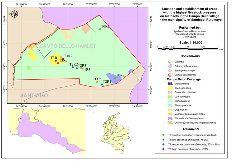
Treatment Structure. Four treatments were established, as follows: T0: Control: Secondary Forest and Wetland. T1: Area with low degradation level (low presence of mounds, <50%). T2: Area with moderate degradation level (moderate presence of mounds, 50% - 70%). T3: Area with high degradation level (high presence of mounds, >70%). Each treatment was replicated three times for a total of 11 experimental units (UE), with each experimental unit covering an area of one hectare and defined by the percentage of mounds present in it.
The sampling of variables in the field was carried out at a depth of 15 cm, both in the "tatucos" and in the adjacent area located 10 cm from the edge.
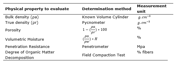
Evaluated Variables. The height and diameter of 30 tatucos (mounds) per experimental unit were assessed, totaling 270 mounds evaluated across all experimental units. Six physical properties were determined (Table 1), both within the mound and in the adjacent area.
Statistical analyses. The statistical analysis of the data was conducted using the statistical software R Core Team (2022). The data were subjected to tests for normality and homogeneity of variance, using the Shapiro-Wilk and Bartlett tests, respectively. After confirming the assumptions, an analysis of variance was performed; the variables that showed statistical differences were subjected to Tukey's mean comparison tests (P≤0.05) using the HSD function from the 'agricolae' package.
RESULTS AND DISCUSSION
Bulk Density (ρa) and Real density (ρr). Bulk density (ρa) showed significant differences (P< 0.05), with a tendency to increase in value when the soil is used for livestock farming. The bulk density (ρa) values found in the treatments had the following results: the highest average was recorded in treatment T1 with low presence of mounds <50%, with a value of 0.27±0.02 g.cm-3, followed by treatment T2 with moderate presence of mounds 50%-70% with 0.21±0.01 g.cm-3. In contrast, the control treatment, T0, in the non-intervention zone had the lowest mean value with 0.12±0.003 g.cm-3. These data are consistent with what has been reported for soils in the analyzed conditions (Figure 2). Treatments that have undergone a change in land use towards intensive livestock farming present higher bulk density (ρr) values compared to the non-intervention zones.
It is important to note that the study area has histosol soils with very low bulk densities, ranging from 0.12 g.cm-3 to 0.22 g.cm-3. According to Moreno-Cáliz et al. (2004), IGAC (2016), Hartemink et al. (2020), and Dos Santos et al. (2020), the apparent density values between 0.09 g.cm-3 and 0.22 g. cm-3 are typical of this type of soils formed by organic materials in an advanced state of revision. In other words, the bulk density depends on the type of organic material and the moisture content at the time of sampling.
The Real density (ρr) showed significant differences (P< 0.05). The values of ρr (Real density) found in the treatments had the following results: the highest average was recorded in treatment T2 with moderate presence of mounds between 50% - 70%, with 1.73 ± 0.055 g.cm-3. In contrast, the lowest (ρr) values were observed in treatment T1, with low presence of mounds <50%, with 1.68 ± 0.030 g.cm-3, treatment T3, with high presence of mounds >70%, with 1.62 ± 0.060 g.cm-3, and treatment T0 wetland with 1.62 ± 0.014 g.cm-3 (Figure 2).
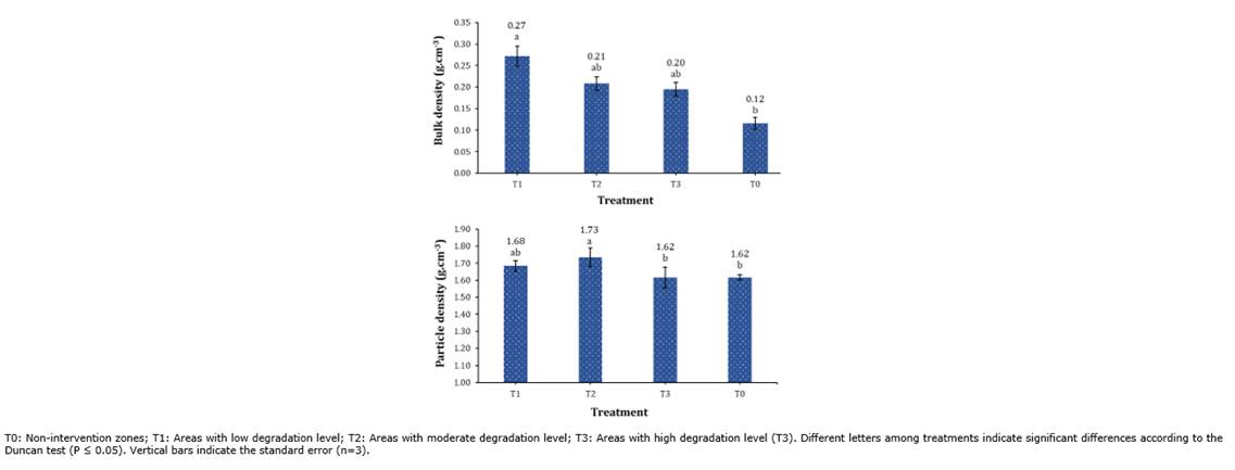
Figure 2 Behavior of Bulk Density and Real Density in Histosols with Different Degrees of Intervention.
In this way, Ángeles et al. (2010) state that real density mainly depends on the composition and quantity of minerals and the proportion of organic matter in the soil. Similarly, Alves-Bispo et al. (2015)reported real density values in the top 15 cm of depth in wet grassland Histosols of 1.40 g.cm-3 and 1.64 g.cm-3, while Caldwell et al. (2007) indicate that particle density in natural organic soils is 1.50 g.cm-3. Therefore, the values presented confirm the high organic matter contents, as evidenced in the study. The values obtained in the research are consistent with those recorded in the soil survey, according to IGAC (2016), where the real density in Campo Bello had ranges between 1.59 g.cm-3 and 1.73 g.cm-3, which are typical ranges for materials of this soil type, classified as very low due to their origin.
According to Bastidas & López (1972), the real density of organic soils in the Sibundoy Valley is 0.98 g.cm-3. This suggests that with the management of these soils and/or the deposition processes of minerals associated with the water bodies in the study area, the quantity of mineral solids present has increased. The above analysis allows us to understand that the values of ρr (real density) change depending on the type of minerals in the parent material and the amount of organic matter in the soil. Organic matter weighs much less than an equal volume of mineral solids; therefore, the quantity and type of inorganic materials in soil significantly affect particle density.
Porosity. This variable showed significant differences (P< 0.05), with a trend towards decreased values when the land use is for livestock. The porosity values found in the treatments had the following results: the highest average was in T0 wetland with 92.8 ± 0.41%, followed by treatments T2 with 88 ± 0.61% and T3 with 88 ± 0.69%, and the lowest was observed in T1 with 84 ± 2.87% (Figure 3).
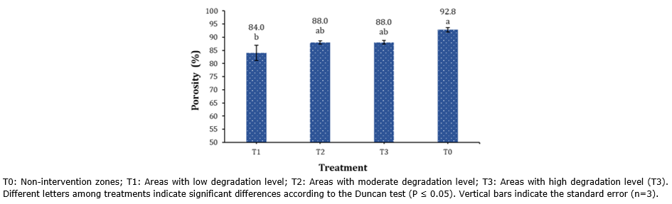
Soil porosity is especially important because it serves as the medium through which water enters the soil, is stored, and moves through it to supply roots and eventually drain the area. It also provides the space where plant roots and soil fauna have an atmosphere, essentially serving as the source of air for them. Values greater than 70% indicate soils with excessive porosity or a high content of organic matter in their composition.
The results obtained in the study agree with the values indicated by Arabia et al. (2020) and for the IGAC (2016) study area, which determined very high total porosity values, ranging between 86.16% and 93.07%, being characteristic of organic materials. These values also correlate well with the apparent and true density data. However, infiltration and drainage are limited by the permanent water saturation to which these soils are subjected due to their geomorphological position (terraced plains). This is important due to the ecosystem function they fulfill since they are located near the upper basin of the Putumayo River, areas that serve as water recharge areas during the rainy season.
Volumetric moisture. This variable showed significant differences (P < 0.05). The values found for this property showed the following results: the highest average was in the T0 wetland with a value of 89.1 ± 3.242%, while the lowest averages were obtained in the T1 with 57.7 ± 6.151%, the T3 with 51.3 ± 3.048%, and the T2 with 49.8 ± 1.039% (Figure 4).
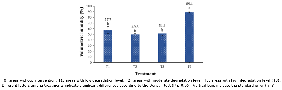
Figure 4 Behavior of Volumetric Moisture Content in histosols with different levels of intervention.
A property of soils with a high amount of organic matter classified as histosols is their high saturation indices" (Warmling et al., 2017)."This is because the smaller the radius of the pores that retain water, the lower the capillary tension, reducing the force with which water is retained in the soil.
Based on the results obtained for this variable, it can be determined that all treatments presented a high moisture content. This is because, as mentioned above, the hydromorphic conditions of the soil are present for most of the year, influenced not only by the location of the study area but also by the evaluation period of these properties, corresponding from August to October 2021, where at the time these months were characterized by the presence of high rainfall, causing that at the beginning of the investigation, the area suffered flooding processes.
However, significant differences were found between natural areas and those used for livestock farming. Treatments T1, T2, and T3 had lower moisture content, which is associated with the amount of pore space. These soils have a lower capacity to store water, partly due to the drainage carried out by producers in these areas, altering their natural conditions when establishing pastures for livestock production.
Diameter and height. According to the analysis of variance, there are significant statistical differences between the treatments (P<0.05) for these variables. The average data for the diameter and height of the "tatucos" indicate that the highest value was obtained in T3 with a high presence of "tatucos" >70%, with a diameter of 151.9 ± 4.462 cm and a height of 22.7 ± 2.59 cm. This was followed by T2, with a moderate presence of "tatucos" between 50% to 70%, with a diameter of 133.4 ± 1.265 cm and a height of 15.7 ± 0.827 cm. Lastly, T1 with a low presence of "tatucos" < 50% had a diameter of 121.5 ± 2.41 cm and a height of 13 ± 0.754 cm (Figure 5).
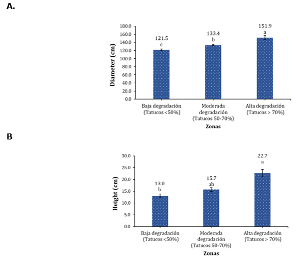
Figure 5 Behavior of A. Diameter; B. Height, of mounds or "tatucos" present in histosols with different levels of intervention. Different letters between treatments indicate significant differences according to the Duncan test (P ≤ 0.05). Vertical bars indicate the standard error (n=3).
This variable is related to soil subsidence, where the "tatucos" indicate the initial level of the soil, and the area surrounding the microrelief shows the effect of soil drainage, excessive load-bearing capacity, and the consolidation process that occurs in these layers as a result of livestock activity (IGAC, 2016).
According to the above and the results presented in T3, it showed the highest averages in diameter (151.9 cm) and height (22.7 cm), indicating the changes in the soils associated with these areas. In these areas, livestock activity has been carried out for longer periods, which has increased the duration of cattle trampling, causing the soil to sink and increasing the presence and size of "tatucos."
Penetration resistance. It is an integrated index of soil consolidation, compaction, moisture content, consistency, and structure. Additionally, it has been correlated with root infiltration. According to Valenzuela & Torrente (2013), there is a relationship between a wide range of soil types, moisture content, and bulk density.
The results show that treatments T1, T2, and T3 exhibit significant increases in penetration resistance compared to T0 (Figure 6). Thus, the surface layer T3 shows the greatest increase with a value of 0.63 MPa, which is 15.7 times higher in resistance, followed by T2 with 0.47 MPa and T1 with 0.41 MPa, representing increases of 11.7 and 10.2 times, respectively. At a depth of 10 cm, T3 shows the greatest increase with 0.44 MPa, representing 1.5 times increase, followed by T2 with 0.43 MPa and T1 with 0.36 MPa, showing increases of 1.4 and 1.2 times, respectively. At a depth of 20 cm, T2 also leads with 0.38 MPa, followed by T1 with 0.33 MPa and T3 with 0.33 MPa, showing an average for the three treatments of 1.2 times. At a depth of 30 cm, T2 shows the greatest increase with 0.39 MPa, followed by T3 with 0.36 MPa and T1 with 0.33 MPa, fluctuating for the three treatments between 1.7 and 1.5 times.
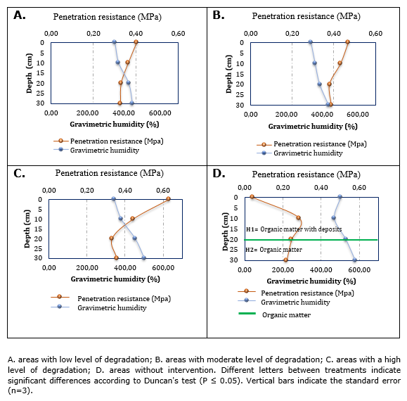
Figure 6 Behavior of the resistance to penetration of the mounds (tatucos) generated in histosols with different degrees of intervention.
The above allows us to establish the effect of the different treatments on soil penetration resistance, showing that in natural areas without livestock intervention, the values of this property are lower than in treatments with such activity. On the other hand, it is determined that as the soil profile deepens, the resistance decreases mainly due to two aspects: a) the pressure of the animal's hooves on the first centimeters and b) the increase in fiber content in the deeper horizons associated with the continuous presence of moisture, as evidenced in the results of this research.
Livestock farming has become a factor that directly affects penetration resistance due to the pressure exerted by the animal's hoof. This is evident in the first few centimeters of the soil profile, where the value of this property is higher and decreases with depth as the fiber content increases. Taboada (2007) mentions that in livestock activities, surface kneading of the soil occurs when it is repeatedly traversed and trampled with high moisture content. Leading to a reduction in pore space, causing not only a loss of soil stability but also a decrease in resistance, resulting in physical degradation due to the sinking of animal hooves into the wet soil and forming small mounds called "tatucos."
In T1, the samples taken from the "tatucos" exhibited low resistance values with an average value of 0.36 MPa and a gravimetric humidity of 400.65%. Compared to T2 and T3, this is due to the conditions found in the study area, which has a low presence of "tatucos" (<50%) because these areas have been used for livestock farming for a shorter period of time.
In T2, which has a moderate presence of "tatucos" (50 to 70%), resistance values of 0.42 MPa and a gravimetric humidity of 382.24% were observed. These values are higher compared to T0 and T1, and this is due to the greater number of livestock per unit area, as reported by the producers. For T3, higher resistance was observed with average values of 0.44 MPa and a gravimetric humidity of 419.9%, indicating greater pressure on the soil due to livestock activity (Figure 7).
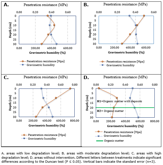
Figure 7 Dynamics of soil infiltration resistance in areas adjacent to the mounds or "tatucos" generated in histosols with different levels of intervention.
The results show that in the surface layer, T3 exhibits the highest resistance with 0.74 MPa, representing an increase of around 18.5 times compared to T0. It is followed by T2 with 0.50 MPa, showing an increase of around 12.5 times, and T1 with 0.35 MPa, with an increase of approximately 8.75 times. At a depth of 10 cm, T3 continues to show the highest strength with 0.53 MPa, representing an increase of around 1.83 times. T1 follows with 0.44 MPa, an increase of approximately 1.52 times, and T2 with 0.42 MPa, an increase of around 1.48 times. At a depth of 20 cm, T2 and T3 show the same strength with 0.34 MPa, representing an increase of around 1.36 times, followed by T1 with 0.36 MPa, also with an increase of about 1.36 times. Finally, at a depth of 30 cm, T1 shows the lowest strength with 0.28 MPa, representing an increase of approximately 1.27 times. This is followed by T3 with 0.25 MPa, an increase of about 1.14 times, and T2 with 0.26 MPa, an increase of around 1.18 times (Figure 7). These differences indicate a significant variation among the treatments, with fluctuations in the relative position of the treatments depending on the depth measured.
For the adjacent area to the tatucos or "soil," in T1, the RP had an average value of 0.36 MPa and a gravimetric humidity of 410.1%. In T2, a resistance of 0.38 MPa was obtained with a gravimetric humidity of 459.57%, and for T3, it was 0.46 MPa with a gravimetric humidity of 399.6%. The results obtained in the samples indicate that there is a higher RP compared to the tatucos in the area surrounding the mound, as this is the area that bears the weight of the animal during grazing.
On the other hand, in T0, the lowest values of infiltration resistance were obtained, with an average of 0.20 MPa and 520.95% gravimetric humidity. These data indicate ease of infiltration with no cattle intervention, as in this case, being a conservation forest for over 38 years and a wetland separated from livestock activity. These data are characteristic of histosol soils. According to Da Rocha (1973) and Thériault et al. (2019), the origin of this type of soil occurs under conditions of continuous water saturation and insufficient oxygen circulation, resulting in slow decomposition of organic matter, allowing its accumulation.
The results show that livestock farming generates processes of soil penetration resistance because the continuous trampling of cattle reduces the pore space. This is also observed in the high values of bulk density, as shown in T3, with the highest resistance values combined with low gravimetric humidity. Ruiz et al. (2000)mention that penetration resistance values are influenced by soil moisture because this property is a determining factor in taking readings. During the drying process, soil particles approach each other, causing an increase in soil resistance values.
Decomposition of organic matter. The degree of decomposition of organic matter was determined by kneading these materials by hand in accordance with the guidelines for soil taxonomy in 2022, observing the amount of fibers present (Bolivar & Ordóñez, 2016). For the control treatment (T0), in general, two horizons were identified. The first one ranged from 0 to 20 cm thick, composed of a layer called "Peat," which, according to Huat (2006), is the accumulation of decomposed plant remains that have been preserved under conditions of incomplete aeration and high water content, meaning in areas with excessive rainfall and poorly draining soil.
For T0 in the first horizon, there is a layer that contains a combination of mineral materials and organic material that remains in an advanced state of decomposition due to sedimentation processes in the area. Therefore, no field-kneading process was required for this layer. In the second horizon, organic materials were found in a greater proportion of fiber in an initial state of decomposition, with a thickness of 20 to 50 cm. For this treatment, in its replicates corresponding to the secondary forest and wetland, percentages between 93% to 98% of fiber were obtained before kneading, and after kneading, it ranged from 41% to 47%. According to the United States Department of Agriculture (2022), the degree of alteration of organic materials corresponds to fibric, containing two-fifths or more than 40% by volume of fibers after grinding, excluding coarse fragments.
For treatments 1, 2 and 3, three horizons were identified, with the first layer ranging from 0 to 25 cm, the second from 13 to 44 cm, and the third from 24 to 50 cm. In the first horizon, fiber percentages before kneading ranged from 1% to 10%, and after kneading, they were between 0% and 2%, indicating a high degree of decomposition of organic material considered sapric. IGAC (2016) states that, generally, the first layer exhibits the highest degree of decomposition due to the aeration conditions it experiences, often as a result of drainage activities carried out on the land. For the second depth, in some sectors of treatments 1 and 2, fiber percentages before kneading ranged from 45% to 75%, and after kneading, they were between 45% and 50%. This indicates a degree of decomposition in a fibric state and is related to the time these areas have been managed with livestock and where the effects of soil drainage have been less pronounced than in the shallower layers, with these areas remaining saturated for most of the time.
On the other hand, in T3, the fiber percentages ranged from 20% to 36%, corresponding to a higher degree of hemic decomposition compared to the other treatments. According to IGAC-Instituto Geografico Agustin Codazzi (1995), these materials are usually found at depths of 25 cm or more in areas that have been drained to greater depths and have been used for livestock activities for an extended period. This prolonged use can influence the decomposition of plant residues. In the deeper layers or horizons for all treatments and their repetitions, fiber percentages ranging from 42% to 85% were obtained after kneading (fibric), indicating organic materials with a low degree of decomposition. Based on the characteristics described in the soil profiles, they correspond taxonomically to Hemic Haplofibrists, euic, isomesic, which are characterized by most of their layers being in an initial stage of decomposition (fibric) and at least one layer between 30cm and 130cm in an intermediate stage of decomposition with a thickness of 25cm. At the family level, according to the pH value determined with CaCl2, it is above 4.5, and its soil temperature regime is established between 8 and 15°C (United States Department of Agriculture, 2022). This aligns with IGAC (2016), which reports that these materials are dominant in the soils of the Campo Bello region due to the organic material composed of plant tissue from the reed beds (totora). This last layer reflects the state of organic matter without anthropogenic intervention, where the decomposition processes through material oxidation have been minimal, preserving their natural characteristics.
CONCLUSIONS
It was determined that the change of use in soils of organic origin, described as Hemic Haplofibrists, euic, and isomesic in the study area currently destined for extensive livestock production, has caused negative impacts on their physical properties. This is how, in the areas with a high level of degradation (T3), an average mound (tatucos) diameter of 151.9±4.46 cm with a height of 22.7±2.59 cm was observed. In terms of physical properties in the area adjacent to the mound, the apparent density was 0.24 g.cm-3, the true density was 1.62 g.cm-3, and the penetration resistance was 0.71 MPa. These values were significantly higher than those observed in non-intervention areas. Therefore, it can be indicated that the change in land use is causing a significant alteration in the physical properties of this type of soil, which is important for the agroecosystems of the southern regions of Colombia.

