


 English (pdf)
 Article in xml format
 Article references
 Send this article by e-mail
 Cited by SciELO
  Cited by Google
  Similars in
SciELO
Similars in
SciELO  Similars in Google
 Permalink
INTRODUCTION
In order to establish land use in the study area, a characterization and typification of the agricultural production systems present was carried out, due to insufficient information and research on agricultural activities in this zone. Understanding these systems could provide a great potential for resources that can be used more efficiently and sustainably (Navia et al., 2019).
According to Criollo et al. (2016), the characterization and analysis of rural production areas are important methods for determining the integral effect of social, economic, and environmental factors, which make it possible to know, understand, and formulate hypotheses about the structure, distribution and management. Likewise, Lotero et al. (2008) state that from a descriptive perspective, it is important to know the interactions of the actors that use the territorial resources and the externalities that are generated.
Elsheikh et al. (2013) argue that there are gaps in systematic landscape assessments, particularly in relation to decision-making contexts at the level of environmental and technological policies. Their research addresses the relationship between landscape and agriculture, which is an important element for land management, crop types, and the effectiveness of policies.
The report "A Climate-Smart Sustainable Agriculture" (2018) underscores that agricultural expansion remains the primary driver of deforestation, forest fragmentation, and the depletion of ecosystem goods and services on a global scale. Mitigating these effects requires the strengthening of information systems, analysis tools, planning and the adoption of environmentally and climate-smart scaled replication practices (FAO & PNUMA, 2020). The "Report on the State of the World's Land and Water Resources for Food and Agriculture" (FAO - Organización de las Naciones Unidas para la Alimentación y la Agricultura, 2021) projects a challenging scenario for 2050, indicating that it will be necessary to increase food production by almost 50%, which will expand the cultivated area in regions with environmental restrictions. This underscores the urgency of modifying cropping patterns and practices through the use of technology for management and adaptation to future changes, promoting sustainable agricultural alternatives, efficiency in the use of natural resources and conservative production strategies. It is crucial to highlight the vulnerability of natural forests to human pressures. The rate of deforestation is estimated to have reached 10 million hectares per year between 2015 and 2020, with agricultural expansion, including local subsistence agriculture, being one of the main causes (FAO- Organización de las Naciones Unidas para la Alimentación y la Agricultura & PNUMA, 2020). These anthropic pressures are intrinsically related to agricultural expansion, generating significant deterioration of natural resources and their consequent fragmentation (FAO & PNUMA, 2020).
In a local context, UPRA - Unidad de Planificación Rural Agropecuaria (2018) highlights the necessity of implementing actions to guide land utilization and the utilization of natural resources, addressing some of the mentioned problems. Therefore, it is fundamental to address land utilization based on the physical conditions of the soils, as well as environmental, social, and economic characteristics. Several research studies have focused on this aspect (Mendas & Delali, 2012, Herzberg et al., 2019; Jaisli et al., 2019; Mwendwa et al., 2019; Geng et al., 2019; Jahanshiri et al., 2020, Mahmoodi-Eshkaftaki et al., 2020;).
Escobar & Berdegué (1990) indicate that methods for classifying production systems can be linked to a number of classification criteria they are based on, leading to the use of univariate or multivariate methods (one-dimensional or multidimensional). There are methodological proposals for the typification and classification of farm systems, such as Escobar & Berdegué (1990), which suggests integrating the determination of a specific theoretical framework, selecting variables at the farm system level (operationalization of the theoretical framework), conducting surveys or other data collection methods, statistical analysis (multivariate), validation of the typology, and classification of new farms.
Therefore, the objective of the research was the characterization and typification of the agricultural production systems from a social, economic, and environmental dynamic. To this end, the most determining agricultural systems were first identified through the collection of primary and secondary information, and then characterized and typified, grouping them into clusters, using statistical techniques for their subsequent description. Ríos et al. (2004) mention that identifying the variables with the greatest influence on land cover change will help to strengthen knowledge and generate management alternatives for regional and local entities. Such procedure will help them to prepare their agricultural development plans with greater certainty, better orient their credit policies and complement their land reordering plans. Therefore, this research evaluated land uses from a social, economic and environmental dynamic in the municipality of Imués, department of Nariño.
MATERIAL AND METHODS
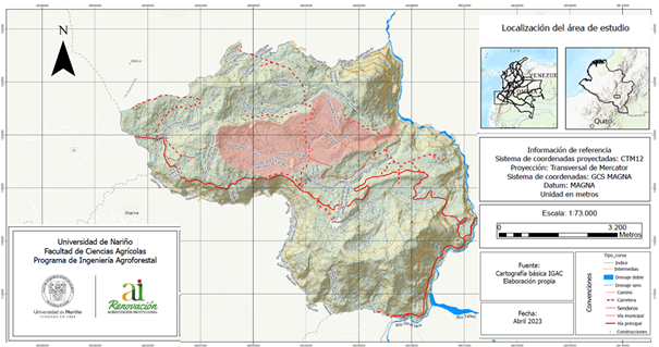
Location. The study was conducted in the municipality of Imués, located in the southwestern part of the Nariño Department, specifically in “La Rasta micro-watershed”. The municipality has varying elevations ranging from 1,600 to 3,000 meters above sea level (Alcaldía Municipal de Imués, 2020a), (Figure 1).
Land Use Characterization
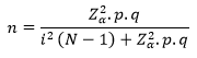
Target Population. The target population of the research was considered through the Alcaldía Municipal de Imués (2020b) and its Secretary of Agriculture, taking into account three identified zones (low, medium, and high) and some characteristics such as area with less than 10 hectares and that their income is derived from agricultural and/or livestock production. The records indicate 725 small producers.
Sampling. A simple random sampling was used, taking 119 producers in the municipality as the population, and the sampling unit corresponds to each agricultural production unit, assuming an error of 5% and a probability of 95%.
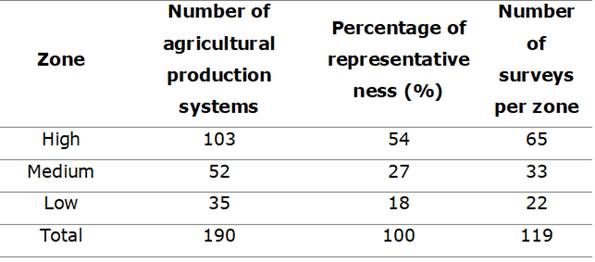
Sample Size Calculation. To determine the sample size, considering it as a finite population, the formula described by Murray & Larry (2009) was used.
Where:
n = Sample size
N = Total population
Z = Critical Z-value, calculated from the tables of the standard normal distribution. Also known as the confidence level (95% confidence level - Z-value = 1.96)
p = Percentage of the population with the desired attribute (0.7)
q = Percentage of the population without the desired attribute (1 - p) (0.3)
e or i = Maximum accepted estimation error (5%)
Stratification. Based on the calculation of the respective formula, a sample size of 119 producers was obtained for this research, which, considering the distribution of agricultural production in the Strategic Plan of the Secretary of Agriculture, Environment and Rural Development of the municipality of Imués (Alcaldía de Imués, 2021), the sample was stratified into three large zones (meters above sea level): low zone (1,690 to 2,200 m.a.s.l.), medium zone (2,200 to 2,560 m.a.s.l.) and high zone (2,660 to 3,000 m.a.s.l.), (690 to 2,200 m.a.s.l.), middle zone (2,200 to 2,560 m.a.s.l.) and high zone (2,560 to 3,000 m.a.s.l.). A random probability sampling per zone was carried out (Table 1), stratified with allocation proportional to the size of the stratum, taking into account the number of agricultural production systems distributed in each zone.
Finally, a random selection was carried out to identify the producers who were evaluated with the instrument for collecting primary information, which for this study was a survey.
Survey Design. For the design, a form was used, which was adjusted according to the methodological proposal of the question criteria of Escobar & Berdegué (1990). The survey used was divided into social, economic, and environmental aspects, with multiple choice, open and closed (single option) questions, originating a structured survey design proposed by Coronel & Ortuño (2005).
The instrument, within its structure, was designed to identify the changes that producers have made in their agricultural production systems based on the capital and means of production they have had access to, as well as the current socio-economic relationships they present (price system, access to credit, forms of land tenure, etc.). In this way, the elements that have influenced the selection and evolution of agricultural production systems in the municipality were observed (Escobar & Berdegué, 1990).
The survey was systematized using the mobile application ODK Collect, which creates forms that include offline data collection, photos, GPS points, and calculations. The application allowed the interviewer to easily access the questions, apply them, upload the information, and synchronize it when accessing to an internet connection through a mobile phone. Additionally, it allowed transferring this information in a tabular format in Excel software for subsequent organization and analysis.
The identified fieldwork routes had the support and assistance of the municipal government through its Agricultural Department, which generated routes, transects, and logistics for locating the producers in the field.
Variables. Based on the survey structure and research objectives, variables were categorized. A category represents the range established for each question within each evaluated dimension, and a variable is a characteristic that identifies or describes each productive unit or farm in the research area. Each set of variables distinguishes one farm or agricultural production unit from another using a limited number of values (categories). Each value of a categorical variable represents a quality or category (Sánchez & Ruiz, 2018). Therefore, the description of the main production systems was based on the variables that obtained the highest values in the multiple correspondence analysis from a social, economic, and environmental perspective.
Based on the above, there were 139 variables (which were submitted for the MCAF analysis), which were used and categorized with their nomenclature. Of these, 42 variables were selected from the social dimension, 67 from the economic dimension and 30 from the environmental dimension, eliminating the rest due to their low variability and weight.
Information Analysis. The statistical program SPAD (Portable System for Data Analysis), version 5.6, was used. The quantitative data obtained from the survey, were recoded into qualitative or categorical types, so that the software could perform the analysis.
Organization and processing of the data for the survey
Once the data were organized, the categorization of the variables was carried out, which consisted of converting each scalar or continuous variable to categorical (recoding them).
Data Organization and Treatment for the Survey. With the support of Excel software, the survey database created and conducted in the field was downloaded from the ODK Collect mobile application. Once the data were organized, the variables were categorized by converting each scalar or continuous variable into categorical ones (recoding them). This way, each category of the variable is considered by the software as a treatable and recognizable unit in the database, allowing for importation from Excel.
Multiple Correspondence Analysis (MCA) for Land Use Characterization. The survey data obtained from the ODK Collect application and stored in the Excel program were imported into the SPAD software, maintaining their variables, categories, and nomenclature. To initiate the MCA, the "Insert method" option was selected in the program, and the "Multiple correspondence analysis" technique was chosen. Then, the selected analysis was executed using the "Run method" option, which generates the analysis results in two different formats: one in Excel and another in a text file.
The file provided a histogram of eigenvalues, which is essential for determining the number of principal factors. These eigenvalues are derived from the structure of association between the original variables, as the MCA allows obtaining factorial planes where it is possible to study the similarity between individuals and the association between variables. Therefore, the objective of the MCA is to detect common information among variables through new variables called factors (Criollo et al., 2004).
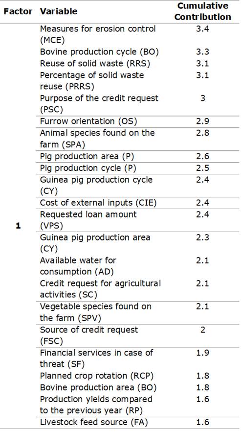
Before subjecting the data to objective standardization and considering the MCA, all variables that showed low variability were eliminated based on the cumulative contribution of each variable to the respective factors. As a result, 51 variables with higher weight or contribution and their nomenclature for each evaluated dimension were obtained (Table 2).
Table 2 Prioritized variables from the resulting factors of the Multiple Correspondence Analysis (MCA).
| System Dimension | Variable and used nomenclature. |
| Social | Zone (Z); Family agricultural participation (PAF); Housing location (UV); Household in the production system (HSP); Farm area (AF); Productive activity (AP); Level of education (NE); Basic services (SB); Access roads (VA); Production preferences (PP); Opportunity to belong to an organization (OP); Land tenure (TE); Land use type_ non-improved pastures (B); Land use type_ permanent crops (CP); Land use type_ house and surroundings (CE). |
| Economic | Production for sale (PDV); Production cycle_ beans (F); Production cycle_ maize (M); Production cycle_ onion (CB); Production cycle_ cattle (BO); Production cycle_ pig (P); Production cycle_ guinea pig (CY); Production cycle_ other (OT); Production area_ beans (F); Production area_ maize (M); Production area_ onion (CB); Production area_ pig (P); Production area_ guinea pig (CY); Production area_ other (OT); Reason for lower land use (RMT); Marketing channels (VC); Cost of external inputs (CIE); Resistance or tolerance to stress (RTE); Economic security (SE); Subsistence production (PAC); Savings (AH); Place of savings (LAH); Reason for not saving (RNA); Credit application for agricultural activities (SC); Source of credit application (FSC); Requested loan amount (VPS); Purpose of credit application (PSC); Total production income (ITP); Total production costs (CTP); Individuals working on the farm (household members and workers) (PTF); Planting (SI); Crop establishment (EC); Seed or seedling source (PSP); Harvesting tool used (HUC); Land preparation (PET); Livestock feeding practice (PAG). |
| Environmental | Fertilization type (TF); Criteria for selecting fertilization type (CTF); Application of amendments (AE); Crop rotation practices (PRC); Plant species cultivated on the farm (ESF); Plant species found on the farm (SPV); Animal species found on the farm (SPA); Available water for consumption (AD); Signs of erosion (SE); Slope of the land (PT); Cover management (MC); Measures for erosion control (MCE); Furrow orientation (OS); Crop residues (RC); Solid waste reuse (RRS); Percentage of solid waste reuse (PRRS). |
Typification of the main production systems.
Determination and description of the selected types. With the results of the MCAF, the researchers proceeded to develop the hierarchical grouping or clustering, establishing homogeneous groups of productive systems and also identifying heterogeneous groupings (Ordóñez et al., 2018). That is, through Ward's hierarchical method (Alvarez et al., 2014; Coronel de Renolfi & Ortuño, 2005; Meneses, 2019), groups with arborescent structures were configured, in the form of clusters of lower levels, which in the hierarchical form are included in others of higher levels. As a result, a dendrogram was obtained, which identified the number of clusters and a file.
RESULTS AND DISCUSION
Characterization of land uses: Multiple Correspondence Analysis (MCA). Eigenvalue analysis: The analysis of the eigenvalue histogram resulted in a total of 238 factors. However, considering the eigenvalue of each factor, which measures the importance of variables and their representation in the production systems, the first four factors were selected (Table 3). These factors accounted for a cumulative percentage of 24.68% (factor 1: 8.16%, factor 2: 6.24%, factor 3: 5.27%, and factor 4: 4.61%).
Table 3 Multiple Correspondence Analysis (MCA).
| Eigenvalue Histogram | |||
|---|---|---|---|
| Factor | Eigenvalue | Percentage | Accumulated Percentage |
| 1 | 0.1618 | 8.16 | 8.16 |
| 2 | 0.1237 | 6.24 | 14.40 |
| 3 | 0.1125 | 5.67 | 20.07 |
| 4 | 0.0914 | 4.61 | 24.68 |
Analysis of Contributions by Factor. This analysis, presented in Table 4, identifies the key variables contributing to the formation of factor one, with a focus on livestock production processes, production costs, income, and environmental management strategies in the studied municipality. The significance of these variables, particularly their impact on soil erosion and waste management, underscores their pivotal role in shaping the environmental conditions of the region. The study emphasizes the need for comprehensive measurement of these processes, incorporating various performance indicators (productive, reproductive, economic, and environmental), as suggested by Navas & Velásquez (2014). This measurement aids in the ongoing assessment of systems, enhances decision-making processes, and facilitates the evaluation of changes within these processes and their outcomes over time.
Within the evaluated farms, those primarily engaged in livestock farming and milk production, often located on smallholdings (0.1 to 0.5 ha), are prevalent. These farms typically raise Holstein cattle (Navia et al., 2015), and the analysis highlights the adverse effects of pasture expansion in steep areas and the fragmentation of adjacent forests on soil properties. Additionally, smaller-scale practices involving minor livestock species like guinea pig farming and pig farming contribute to income diversification in the high Andean region, albeit on a smaller scale (Rojas, 2020). The study aligns with regional statistics, highlighting the concentration of small landholdings, which has led to intensive land use and, in some cases, encroachment into natural areas, resulting in forest fragmentation and, in certain zones, a complete lack of tree cover (Jara et al., 2020).
Despite the challenges posed by cattle ranching, traditional practices aimed at mitigating soil degradation are observed, including erosion control measures, crop rotation, and solid residue reuse. These practices suggest the incorporation of agroforestry techniques for soil and water conservation, as emphasized by Sarasty et al. (2017). However, the analysis also reveals that farmers often allocate more than 60% of their income to external inputs for crop production, leaving about 20% for healthcare, education, and housing. Due to a lack of academic studies and the necessary knowledge for effective resource management, they face difficulties in making technical, economic, and administrative decisions. Challenges related to obtaining loans from banks are further exacerbated by the banks' limited understanding of rural dynamics, hampering producers' access to suitable credit adapted to their production systems. Consequently, the inefficiency in natural resource use leads to low productivity, primarily supporting subsistence farming with significant environmental impacts, as documented by Angulo (2012) and Cifuentes & Muñoz (2008).
In the second factor (Table 4), the variables that stand out are those that indicate that agriculture is the main activity in the three identified zones. This activity generates the highest income for families and employs a large amount of informal labor in the territory. Although agriculture also contributes to the diversity of production for self-consumption, production costs, and sales do not generate significant profits or surpluses, which hinders savings and timely payment of credit debts. In addition, the particular climatic conditions in the area often subject crops to stressful situations.
Corn, a widely grown agricultural product, is a staple food in many areas and is also used as a livestock supplement in some cases. In addition to corn, fruit trees such as tree tomatoes, avocados, coffee, mangoes, and others are grown in the lower zone of the municipality, which can generate additional income through commercialization, exchange, or self-consumption. These highly varied and diverse production systems require a wide range of variables adapted to the heterogeneous conditions of the local agricultural sector and are vulnerable to external factors, as noted by Analuisa et al. (2020).
Regarding maize cultivation in particular, some authors attribute low production to poor agronomic management, such as the use of uncertified seeds and the lack of modern techniques. This is mainly due to farmers' lack of monetary resources to invest in new technologies and their lack of economic capacity to assume the risk associated with these activities. Smallholdings are a common characteristic in these areas, with plots ranging from 0.1 to 0.5 ha, and in some cases, the productive system is developed far from housing areas, discouraging family participation in productive processes. This, together with the migration of youth and adults in search of better income, has weakened the social structure and local agriculture over time, which translates into an additional constraint to invest in agriculture in the territory (López et al., 2019; FAO - Organización de las Naciones Unidas para la Alimentación y la Agricultura, 2012; Quiroz et al., 2003; Fonte et al., 2012; Arnesto & Benavides, 2003).
In the third factor (Table 4), small-scale producers in both the lower and middle zones of the municipality exhibit a preference for establishing traditional polycultures. This strategy involves diversifying crops in the field, resulting in higher productivity in terms of usable products per unit of area compared to monocultures managed at the same level (Merma & Julca, 2012). This diversification of cropping systems is likely influenced by the altitudinal ranges in the area and the favorable climate, which allow the cultivation of multiple crops and a variety of livestock. Furthermore, these farmers engage in intercropping practices, particularly incorporating leguminous species for rotation.
Legumes are seen as a valuable component of polyculture systems for their ability to minimize crop failure under unfavorable conditions, stabilize yields, and maintain soil heath (Banik et al., 2006; Narváez et al., 2010; Fonseca & Vega, 2019).
While agricultural products are commercialized in the capital of the department and neighboring municipalities, providing a secure marketing channel, the lack of a stable market for diversified crops poses challenges for local farmers. Inadequate marketing environments in the evaluated zones hinder the proper functioning of the agricultural market in the municipality, with intermediaries often benefiting more economically than the farmers. To address this issue, it is crucial, as suggested by Dixon et al. (2001), to establish a competitive market environment with numerous active buyers, especially for small-scale producers with limited market access.
The absence of livestock systems in this factor is attributed to farms’ steep slopes, ranging between 35% and 45%. Soils with such slopes are more susceptible to erosive phenomena, leading to mass removal or desertification during rainy or dry seasons due to the lack of vegetative cover. Farmers likely recognize the risks associated with livestock activity in their work areas, which may deter them from engaging in livestock farming due to the potential adverse effects on their land (Arostegui & Sáenz, 2014; Swinton & Quiroz, 2003).
Factor four (Table 4) is characterized by the criteria used in selecting fertilizers, seed origins, farm area management, and mechanization systems, all of which significantly influence decision-making within agricultural activities. The current context underscores erosive processes, a reliance on traditional agriculture with limited innovation, resulting in insufficient economic income to meet fundamental family needs.
Notably, poor agricultural management, including the excessive use of chemical products and mechanized equipment for soil preparation and harvesting, has been a determining factor in the crisis and decline of barley cultivation (Ávila, 2020). This approach, aimed at achieving higher productivity, comes with substantial costs, often beyond the means of small-scale producers, and has adverse effects on soil physical properties, directly and indirectly diminishing soil productivity (Guerrero et al., 1977). As highlighted by Arteaga et al. (2016), these conventional production practices in the Andean region have led to progressive deterioration, including soil degradation, as a result of factors such as indiscriminate fertilizer use and the use of inadequate technologies for crop cultivation and harvesting. These practices surpass the soil's natural regenerative capacity, leading to the depletion of soil resources, reduced production, and lower yields per unit area. Consequently, these processes have severe repercussions in agricultural areas, including erosion, soil fertility loss, organic matter depletion, and soil acidification, contributing to environmental degradation, crises in family farming units, and a diminished quality of life for local communities (Leyva et al., 2018). Arévalo & Del Castillo (1999) and Navarro (2018) further emphasized the alarming situation in the municipality, characterized by evident signs of severe erosion in a significant portion of the areas subjected to this type of land use over time.
Determining and describing the clusters.
Using the information obtained from the AFCM, a cluster analysis was conducted to group similar productive systems based on the four factors and their qualitative characteristics. This analysis aimed to form four well-defined groups or clusters characterized by their intra-group affinity and inter-group differences among productive systems, as shown in Table 5.
Table 5 Identification of productive systems for each defined group.
| Grup | No. | % | Sistemas productivos |
|---|---|---|---|
| 1 | 62 | 52.10 | 57, 50, 45, 37, 51, 56, 67, 65, 63, 98, 8, 10, 68, 84, 95, 64, 66, 69, 62, 61, 55, 52, 53, 58, 42, 41, 40, 36, 39, 94, 59, 35, 54, 90, 96, 32, 33, 38, 34, 23, 27, 107, 19, 21, 17, 22, 18, 15, 24, 12, 14, 29, 31, 25, 13, 6, 30, 26, 7, 11, 9, 1 |
| 2 | 11 | 9.24 | 101, 105, 99, 103, 100, 104, 102, 48, 47, 49, 46 |
| 3 | 24 | 20.17 | 74, 72, 77, 75, 78, 73, 89, 87, 88, 76, 85, 86, 20, 97, 4, 16, 3, 5, 83, 43, 2, 44, 93, 28 |
| 4 | 22 | 18.49 | 81, 80, 92, 70, 82, 71, 60, 91,114,110,111, 108, 106, 109, 119, 118, 115, 116, 113, 117, 79, 112 |
The obtained dendrogram, illustrated in Figure 2, identified each of the branches and expressed the association of farms into four distinct groups with a Ward index of 0.8 (cluster quality), which was used for the cluster analysis of the data. This method grouped the productive systems in a way that minimized the sum of variances within each group. In other words, it sought to form clusters that minimize internal variability within each cluster, which was calculated by the software through the calculation of the Euclidean distance between cluster centroids (central points). Then, the groupings that minimized the intra-cluster variance after merging were combined. Finally, considering the suggestions of Alvarez et al. (2014) and Coronel de Renolfi & Ortuño (2005), it was determined that working with four clusters improves the accuracy of the resulting information.
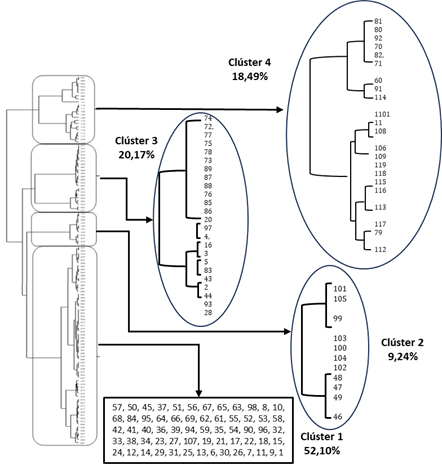
Based on the research objectives, methodology, and selected variables, each cluster was identified as an adaptation of the conventional agriculture approach associated with land use type. This finding highlights that producers make social, economic, environmental, and organizational decisions within the municipal context.
Cluster Analysis
Table 6 shows the information and the clusters for each of them and their variables and percentages obtained. Following are the analyses for each cluster.
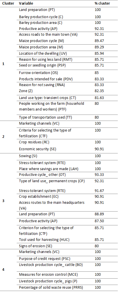
Cluster 1
The first cluster, encompassing 52.10% of the total sample, comprises 62 farms primarily located in the middle zone at altitudes ranging from 2,200 to 2,560 meters above sea level. These farms predominantly engage in the cultivation of transient crops, which make up 30-60% of their total land area. Maize and barley cultivation are the core activities carried out on small-scale micro-land areas of 0.5 to 1 hectare, with production cycles spanning 5 to 10 months. Farm operations involve animal traction for land preparation, and seed selection is undertaken by the farmers themselves. This cluster's production typically revolves around 2 to 3 products, including maize, barley, and bulb onions, intended for sale (Table 6).
The households associated with these farms are dispersed across rural areas, and the labor force varies from 5 to 15 individuals, encompassing both household members and hired workers. The presence of private roads and reliance on bicycles for transportation suggests that these productive systems are situated in marginalized regions of the municipality, characterized by limited access to urban centers, basic services, and commercial activities. This challenge hinders their access to certain conditions such as access to land, productive alternatives and expansion of the agricultural frontier that affects environmental deterioration (Sánchez et al., 2011).
Cluster 2
The second group (Table 6), comprising 11 farms, representing 9.24% of the total agricultural systems, focused in the sale of various products, including milk, maize, beans, onion, barley, potatoes, coffee, vegetables, and small livestock. They utilize both secure and unstable marketing channels, which are influenced by factors such as road closures, price fluctuations, and intermediaries engaging in price speculation. Notably, this cluster's decision-making process includes considering fertilizer costs when selecting crops, leading to inefficient soil usage without soil analysis, as highlighted by Álvarez (2019). Excessive fertilizer use contributes to higher production costs, raising concerns about environmental sustainability due to energy consumption and its impact on natural resources. Despite being a minority group, these farmers actively participate in community action boards, providing economic security in the face of threats. They implement measures like the reuse of crop residues and prioritize the improvement of marketing channels, recognizing the associated costs and their reliance on agriculture for livelihoods, aligning with the recommendations of Wymann von Dach et al. (2014) regarding diversified marketing channels' advantages in terms of distribution, delivery points, and purchase prices to benefit producers.
Cluster 3
The third cluster (Table 6), consisting of 24 farms (20.17% of the total), primarily devoted to agricultural crop cultivation, although farming is not their main occupation. These farms are located in the low zone of the territory, ranging from 1,690 to 2,200 meters above sea level. Despite pursuing other activities, 87.50% of these farms have fruit trees for both subsistence and commercial purposes, allocating 60% of their land to small working areas. While 92.31% purchase seedlings for planting, they do not use fertilizers. Interestingly, all these producers report that their production systems can withstand droughts and intense rainfall with rapid recovery, although erosion signs are not widely perceived despite being observed in some farms. Additionally, these farmers save money in financial institutions, and their main access roads are often bridle paths, potentially hindering agricultural production and commercialization.
This cluster's analysis reveals limited farm diversity, impacting biodiversity and connectivity with natural spaces. Farmers in this group tend to adapt to market fluctuations, even if this involves high costs related to external inputs, as long as the overall economic income remains positive. Such adaptation may lead to excessive soil use, agricultural frontier expansion, or the overuse of agrochemicals. Notably, these farmers focus on agriculture, emphasizing planting systems, environmental conditions, crop timing, and diversification to generate income consistently throughout the year, as outlined by Álvarez (2019).
Cluster 4
The fourth cluster (Table 6), consisting of 22 farms and representing 18.49% of the evaluated population, is exclusively dedicated to livestock farming, encompassing cattle, pigs, and guinea pig farming, often integrating silvopastoril systems as a complement to their livestock activities. These farms exhibit proactive practices for erosion control, including furrow orientation perpendicular to slopes, demonstrating their commitment to sustainable land management. Moreover, a majority of these farms, over 60%, effectively reuse solid waste, and 85% implement planned crop rotation, reflecting their comprehensive approach to resource optimization and conservation. Mahecha (2003), mentions that the more complex the system, the more benefits it will provide, considering the type of forage species to be used, their susceptibility to soil type, climatic conditions, shade and the appropriate density. On the other hand, Ibrahim et al. (2006) emphasizes that this type of exploitation allows a diversity of products such as milk, meat, wood, poles and firewood, reducing in part the external inputs for the farm and favoring the generation of environmental services.
This cluster enjoys favorable conditions, notably abundant water sources in the highland areas that fulfill the requirements for housing, livestock, and plant cultivation. These attributes enhance the resilience of their productive systems, enabling them to respond effectively to external and internal pressures, which bolsters their long-term sustainability, aligning with findings by Pita et al. (2018). However, there is a perceived significance in the cost of inputs utilized in their agricultural activities, with credit loans from financial institutions covering a substantial portion, ranging from 30% to 60%, of the total production costs. Unlike previous clusters, this group recognizes the existence of two marketing channels, yet both are deemed unsuitable for their activities due to intermediation or cost-benefit concerns, limiting the generation of adequate production surpluses.
This cluster exhibits strengths in ensuring family subsistence, characterized by the integration of various elements into their farms, leveraging existing capital, embracing higher technological levels, and actively participating in the market. Structural changes within their productive systems, including the adoption of agroecological models, are noteworthy and contribute to improved conservation of natural resources. The cluster encompasses a mix of entrepreneurial and traditional peasant production practices, with some farms already consolidated or nearing consolidation, reflecting the impact of agricultural forms on their current state. The economic dimension is emphasized, as it plays a pivotal role in shaping their production cycles to ensure year-round income, supporting their essential needs in the region. However, variable marketing channels present challenges, contributing to increased expenses and potentially leading to reliance on loans from the banking system.
According to Lattuada et al. (2015), this type of grouping generates some benefits such as the reduction of some risks inherent to these activities, access to different programs and strengthening of income within the activity. Lattuada et al. (2015), emphasizes that there is a contribution in terms of economic and social welfare for its participants, which leads to opportunities for improvement.
CONCLUSIONS
The research identified four distinctive factors within the Microbasin Farm Association (AFCM), influenced by climatic interactions and altitudinal range. Each factor is related in a complex way to the natural environment and is based on specific characteristics of agroecosystem diversity and productive systems.
The AFCM revealed particular characteristics in the productive dynamics of the micro-basin. Cluster 4, predominant in the middle and high areas, focuses on livestock exploitation and uses silvopastoral systems. These practices promote the connectivity of the ecosystem with the forest relics present in the area, thus contributing to the sustainability of rural activities.
Clusters 1, 2 and 3 have traditional land use practices. However, its unplanned management has negative consequences on soil resources, manifested in processes of erosion and forest fragmentation. These impacts are aggravated by the expansion of the agricultural frontier in the region.

