


 text in
  English (pdf)
 Article in xml format
 Article references
 Send this article by e-mail
 Cited by SciELO
  Cited by Google
  Similars in
SciELO
Similars in
SciELO  Similars in Google
 Permalink
1. Introduction
Geological faults in the homes of the inhabitants of Mexico City (CDMX) are caused mainly by horizontal or vertical dislocation in certain parts of the lithosphere, composing a latent risk to their peace of mind and integrity; therefore, the establishment and urban growth in some areas ignores the geophysical composition of the subsoil, establishing housing constructions in risk areas.
This analysis focused on geological faults that originate or are activated by certain factors, causing the rupture of various parts of the soil, specifically the surface and subsoil, creating damage to the structure of homes established on these faults, which creates a latent risk to the population, which could lead to possible relocation or loss of property.
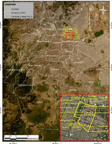
The study area is centered on the street Quinta Cerrada de la Avenida 503 Colonia San Juan de Aragón 1ra Sección alcaldía Gustavo A. Madero, CDMX, damaging approximately 14 houses due to a geological fault; houses that presented fractures in floors, walls and roofs of the homes (Figure 1), the above, mapping in detail with the support of Geographic Information Systems (GIS) to know the location of such geological damage.

Estimating displacement caused by faults is a very relevant parameter in geological and geophysical studies focused on housing damage, providing relevant information on quantifying and measuring deformation sites forming boundaries and understanding territory according to existing topographic features (Alonso, Fitz, and Gutierrez, 2020).
Visually, the failures caused by the activation of geological faults cause fear in the population due to the size of these cracks. It is vital not to cause fear in the population based on geotechnical and soil mechanics studies but to protect the population by promoting basic explanations, preventive measures, and correction or repair of the damage.
In the CDMX, some buildings are at risk of total or partial collapse due to the effects of geological faults; therefore, the objective is to study the damage cartographically to monitor displacements and location of houses in fault zones, avoiding damage to infrastructure and economic losses (Hernández and Láriz, 2015).
The precise cartographic identification of regions with faults derived from geological faults will be beneficial to managing risk management processes, creating permanent monitoring in parts where there are fault strips, promoting civil protection, and not only damage correction.
Likewise, for cartographic identification and risk management, it is prudent to know that water extraction due to the overexploitation of aquifers in the CDMX still predominates; approximately from 1990 to date, many urban areas of central Mexico have been damaged by differential soil subsidence, causing failures which have occurred more frequently recently (Garduño, Arreygue, Israde, Rodríguez, 2001).
The drying up of the water table is an important factor in activating fracture zones or geological faults; therefore, overexploitation according to water extraction greatly promotes the breakage of the lower parts of the soil, something that should be considered and attempts to minimize possible damage.
In Mexico City, there is a record of 59I sites of fracturing or subsidence of the subsoil; some experts have even detected I2 sites in the capital with critical deformation, located in various neighborhoods in the municipalities of Iztapalapa, Iztacalco, Tláhuac, Cuauhtémoc, Benito Juárez and Xochimilco (Congreso CDMX, 2023).
The above quotation details the current municipalities where there is evidence of fractures that must be accurately mapped according to geological, geomorphological, geographical, and seismic information to constitute containment measures in the event of a major fracture that could risk the inhabitants' lives.
It is crucial to know the properties that encourage the activation of geological faults; the study of geography focused on urbanism should be examined with the support of geophysics and geomorphology to establish accurate mapping according to qualitative and quantitative elements, working them theoretically using methodology through map algebra, ratifying them empirically and their contribution is substantial for the protection of the population.
Specifically, the general direction of the manuscript is the concerted execution with the population of urban reconfigurations due to geological faults that undermine the tranquility and safety of the inhabitants and neighbors in general of areas surrounding the site of damage, the above, through the application of digital mapping, This can be methodologically replicated in other parts of the CDMX, of the Mexican Republic or in different parts of Latin America, where the geographic, geophysical, geological, edaphological, geomorphological, hydrographical characteristics, among others, are similar to the study area of this article.
After the introduction, this document presents in the theoretical framework previous studies on the problem, some of which deal with the understanding of geological faults and damaging effects in cities; the third section presents the methodological approach using data from the leading institutions in charge of studying geological and seismic issues in the Mexican national territory; The fourth section presents the different vectorial cartographic techniques derived from geomatics and information from INEGI, National Risk Atlas and SGM, intending to identify urban areas at risk; in the discussion section the results are analyzed and finally, the conclusions section is presented, where the importance of implementing the cartography obtained in houses established in sites with some degree of risk is highlighted.
2. Theoretical framework
The analysis of the present study focused on urban risks due to geological faults should be examined according to previous studies that deal with the problem; it is prudent to mention that some studies were found that address the understanding of geological faults that partially study their occurrence and damaging effects in cities, noting that there is still much work to be done in the future, specifying that at present the existence of geological faults is increasing. The monitoring of housing to determine structural damage is of vital importance, qualitative and quantitative parameters should be established to know the typologies of the geological fault, matching at all times the geoposition of the fault with the existing urbanism (Hernández and Láriz, 2015).
People observe fractures and cracks in the ground when they affect their homes, including several uncommon sounds that sometimes alert possible activations of faults and, therefore, failures in homes; therefore, the mapping accuracy may show the homes that may be damaged in their architectural structure. On certain occasions, the horizons or fault planes reveal sets of superimposed striations with different orientations, which may classify with a certain degree of precision possible activations or reactivations of the fault blocks and the possibility of establishing protection mechanisms for the homes (Escamilla, 2019).
It is very important to have constant communication between residents and governmental entities in charge of civil protection in the various municipalities in the CDMX; the information and notice from neighbors to the authorities may establish some degree of security in them and analyze the potentially affected area, to avoid possible catastrophes, pointing out that many of the damage to homes is mainly due to disproportionate urban growth in the CDMX, building without knowing the geographical characteristics of the site.
The regional urban growth in Mexico during the twentieth century, related to its economic and social impact, has resulted in a highly uncontrolled demographic process forging complex problems, causing various risks in the cities themselves that are severely affected according to geography; therefore, it is important to mention that the geographical characteristics of the soil were hardly chosen or studied; currently fostering various natural hazards that violate the tranquility of residents (Perez, 2014).
The current inadequate urban planning is preceded by planning without control or vision; the CDMX has such diverse problems that it is complex to quantify them due to the high number of unplanned urbanism; therefore, hundreds of neighborhoods in the city are diminished by floods, earthquakes, landslides, sinkholes, geological faults, among others, seriously damaging homes and the integrity of families.
Seismicity in Mexico is increasingly recurrent, to remember this, the present analysis refers to earthquakes in previous years that have devastated the CDMX, therefore, the importance of the materials with which a house is built is very significant, avoiding at all times self-construction, by not having a professional structure depending on the geography of the site (Contreras y Winckler, 2013).
The degree of self-construction in the CDMX is increasingly recurrent due to the socioeconomic level of the population, which further increases the risk of housing collapse due to geological phenomena caused by failures; it is prudent to gradually but permanently stop the unprofessional construction that may cause housing problems in the future.
Approximately since 2016, the duties of the governmental state in the face of disaster risk management have been analyzed, implementing factual situations that serve as input to conclude that said state is responsible for the damages derived from the neglect in disaster prevention derived from geological faults; something that continues to increase not finding a solution so far (Acuña, 2016).
Disaster prevention should be the civil protection objective of any federal, state, or municipal government in Mexico. The damages caused by natural events are so significant and recurrent that the existence of omission on the part of governmental authorities in matters of risk aggravates urban problems; therefore, it is prudent to consider that the correction of the damage is not enough to protect the population, leaving to work mechanisms of prevention and not only of damage repair.
The representation of seismic hazard in any city historically affected by earthquakes will remain vulnerable to possible geologic faults, resulting in probable devastation to housing and causing loss of life (Zambrana, 2021). Earthquakes and geological faults share the same element: the damage to several houses, even more so when they lack geographical safety and safe architectural structure based on civil engineering elements. The proposal of social risk management refers to the agreement between inhabitants and governmental entities, should allow a comprehensive study, linking hazards and vulnerabilities, examining the different scales enabling the determination of risk areas, which will have to be connected to spaces where there is a greater urban concentration, proposing measures to avoid potential damages (Montezuma, 2011).
Determining risk areas interpreted using geoinformatics systems, commonly known as GIS, will establish important precisions in the areas to be evaluated, referring to the crossing of information employing map algebra. Therefore, it is essential to have updated vector and satellite cartography to identify and establish risk percentages.
Photo-interpretation using aerial images constitutes one of the most advanced and convincing sources of information for data updating, sometimes related and complemented with satellite data, which organize elements of great importance for geographic studies (Bolaños, 2023).
The usefulness of photo-interpretative elements will be relevant for studies that analyze geomorphological risks. The advance of geotechnologies is very significant, allowing its use and interpretation of images almost in real-time, evidencing certain damages visualized entirely depending on the scale of work, therefore, the usefulness of GIS is of great contribution in this research article.
This theoretical section exemplifies possible solutions to urban risk due to the presence of geological faults, which will help to understand the potential failures in the population housing and, thus, to alert and protect people living in risk areas.
Seismicity and relationship with geologic faults
There is such a close relationship between earthquakes and geological faults that, on most occasions, they implant a reactivation and movement in the subsoil, causing the existence of large faults, pointing out that other geophysical actions can also originate them.
The relationship of the study of earthquakes with geological faults establishes several parameters that determine the intensity and magnitude of the damage and potential cracking in parts of the subsoil, evidenced in the immediate segments near the floors of the houses (Pérez, Aguirre and Ramírez, 2018).
It is essential to understand that when a seismic movement occurs, the oscillatory and trepidatory waves institute the existence of faults that, at the beginning, are not visible to the naked eye. However, their exit and evidence will occur over time; remembering that the CDMX is still an endorheic basin, which, due to its geographic characteristics, is very susceptible to sinkholes and geological faults due to its edaphology, hydrography, geomorphology, and geology.
Approximately from 2001 to date, several urban areas in the CDMX have been permanently damaged by differential ground subsidence, known among the population as sinkholes or cracking, usually linked to earthquakes and overexploitation of aquifers (Garduño et al., 2001).
An extra component that establishes several damages in the soil and, therefore, in the houses is the overexploitation of aquifers, which dry out large regions due to the large extraction of water so that when some telluric movement occurs, it will generate a more outstanding breakage of the lower parts of the soil; promoting cracking resulting in significant geological faults.
The following are the event details to clarify what happened in the San Juan de Aragón 1st Section neighborhood.
A geological fault caused I4 homes in the San Juan de Aragón Primera Sección neighborhood in the Gustavo A Madero district to suffer structural damage to their homes, five of which have severe problems, informed Myriam Urzúa, Secretary of Integral Risk Management and Local Civil Protection. Since Monday morning, neighbors reported a crack, which not only caused a water leak reported more than six months ago in Quinta Cerrada on Avenue 503 to become even more significant but also affected 14 houses, some of which have fractures in floors, walls, and roofs (Mendoza, 2021).
The structural damages in the houses established moderately in geographically safe areas according to the slope of the land did not guarantee that the urbanism established in those areas was safe, therefore, it is essential to note that most of the characteristics of the territory should be known to minimize the risk; what happened in San Juan de Aragón shows that some non-visible risks can be activated over time and relocation processes can be conceived due to the high level of risk.
3. Methodology
As a result of the above, we worked with data from the main institutions in charge of studying geological and seismic issues in the Mexican national territory, obtaining information from INEGI (National Institute of Statistics and Geography, 2002) and from the latest update of the National Risk Atlas (Atlas Nacional de Riesgos, 2023).
It is essential to clarify that these data were only chosen to observe their importance and update, with which the Mexican government works to face urban risks due to geological faults in the CDMX.
First, mapping the main seismic zones in the CDMX was obtained, observing certain edaphological, geological, and geomorphological characteristics and identifying the area where the San Juan de Aragón 1st Section neighborhood is located (Figures 2 and 3).


Figures 2 and 3 show that the study area is located within seismic zone IIIC, which has a type of soil composed of very soft and compressible lacustrine deposits due to the high water content, favoring movements in the lower parts of the soil; for a better understanding, these seismic strips are differentiated below by the Mexican Geological Service (SGM).
Zone I, firm or hilly: located in the highest parts of the valley basin, it is formed by highly resistant and not very compressible soils.
Zone II, or transition zone, has intermediate characteristics between Zones I and III.
Zone III or Lake Zone: located in regions where lakes were formerly located (Lake Texcoco, Lake Xochimilco). The soil type consists of very soft and compressible lake deposits with high water contents, which favors the amplification of seismic waves (Servicio Geológico Mexicano, 2017).
According to the cartographic analysis referenced, seismic waves and their relationship with geological faults exemplify that the study area is very prone to the existence of geological faults due to the edaphological composition of the soil; therefore, it is important to use this mapping to prevent risks in the municipality of Gustavo A. Madero, even the advance and risk is amplified in the eastern part of the same municipality; pointing out that in the future the urban advance should be supervised, which will establish greater damage in the municipality.
4. Results
For the implementation of the methodology of this article, vector cartographic techniques derived from geomatics and information from INEGI, National Risk Atlas, and SGM related to civil protection against geological phenomena and photointerpretation were used to identify urban areas at risk.
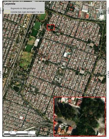
Cartographically, the San Juan de Aragón 1st Section neighborhood was located with the support of ArcMap GIS using the Open Street Maps tool, which shows the urban characteristics and the central existing neighborhoods near the evaluated neighborhood (Figure 4).
The previous figure shows the current urban expansion in the San Juan de Aragón 1st Section neighborhood, which is practically wholly urbanized, thus the urgency of supervising possible geophysical damage and its relationship with the increase in urban risk.
According to journalistic reports, the crack began in Quinta Cerrada de la Avenida 503, damaging 14 houses and extending approximately to Avenida 505 (Mendoza, 2021), therefore, the crack was empirically located with the support of photo interpretation, pointing out that according to neighbors in the area, it extended even more visually (Figure 5), specifying that its internal non-visual extension may be even significative in terms of its length, affecting a greater number of houses in the future; The failure zone also includes the Nepal primary school and the San Juan de Aragón Health Center (Figure 6).
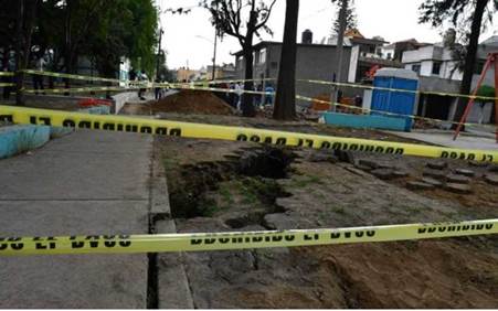
Source: Mendoza, 2021
Figure 5 Geological fault Quinta Cerrada avenida 503, Colonia San Juan de Aragón Ira Sección.
Source: Own elaboration
Figure 6 Cartographic location of the geologic fault in Quinta Cerrada Avenida 503, Colonia San Juan de Aragón Ira Sección.
According to the sample in Figures 5 and 6, the initial geological breakdown of the study area is observed, therefore, the attention of experts in geophysics, geology, and geography, with the scoop to establish studies with fissurometers, portable electronic equipment of high sensitivity and radon gas detectors, identifying the houses that have a high and very high level of risk to a possible collapse of buildings.
5. Discussion of results
Following and derived from the damage to the homes of people living in areas that initially did not have any geological, geophysical, geomorphological, hydrometeorological, or edaphological risk, among others, the high degree of risk that is not visible, causes the sudden occurrence of cracks to unexpectedly affect the lives of populations that were usually located in geographically safe areas.
It is very important not to confuse or establish as synonyms the terms hazard, vulnerability, and risk, specifying that, in the present study focused on geological faults, the hazard is the appearance of cracks resulting from friction or sudden movement in the lower parts of the ground, which will occur without prior warning.
The element to be reduced is vulnerability, precisely with the study of cartographic, geographic, geological, geophysical, and social risk management elements derived from the constant work between scientists, politicians, and inhabitants to institute civil protection against possible activations of geological faults in urban areas.
Therefore, the level of risk can be substantially reduced, understanding that it results from hazard and vulnerability. Reducing vulnerability and, thus, risk will protect the inhabitants from possible cracking that may affect their homes due to partial or total collapse. It is important to question that the social management of risk in the face of a possible disaster is currently insufficient, rectified by the multiple geological, hydrometeorological, geomorphological, and geophysical faults, which occur constantly and are so evident that the population waits for a disaster to occur to institute recovery mechanisms themselves.
Finally, it should be noted that post-disaster civil protection in the CDMX is adequate to a certain extent; however, avoiding damage and not only repairing it will be substantially more beneficial for the population, which will be able to prepare itself through preventive and warning methods in case of any geological damage that may affect their homes.
6. Conclusions
The analysis from the theoretical and methodological component is of utmost importance since the existing geological faults in the municipality of Gustavo A. Madero are mainly due to the composition of the soil, in contrast to the municipalities of Álvaro Obregón, Magdalena Contreras, Cuajimalpa, and Tlalpan, which do not have geological faults; pointing out that the presence of sinkholes in Miguel Hidalgo and Álvaro Obregón is due to the existence of mines, which is a different fact.
Geological faults based on what happened in San Juan de Aragón 1st Section, evidence that they will most likely intensify in the eastern part of the municipality of Gustavo A Madero; however, constant supervision should also be established in the municipalities of Venustiano Carranza, Iztacalco, Iztapalapa, Xochimilco and Tláhuac (Figure 2).
It is very important to use geoinformatics mechanisms and portable electronic equipment of very high sensitivity to know the existence of cracks and establish averages before their propagation, pointing out that radon gas detectors are currently the most used in such studies.
The intervention of multidisciplinarity, interdisciplinarity, and transdisciplinarity will promote possible solutions to the problems mentioned above, the permanent flow of information between physical and social sciences, encouraging each of them to analyze components to avoid major risks due to geological faults, even more so when the possible increase in size and depth of these cracks may create accidents causing deaths in the population.
The methodology and cartography should be implemented in the future permanent security in houses established in sites with some degree of risk; the contribution of GIS mapping will be a substantial and accurate contribution at the time of establishing possible urban reconfigurations or implementation of civil protection mechanisms in the population, therefore, I the importance of studying each of the components that lead to a more significant failure induced by geological faults.

